|
Metropolitan Area
Dallas Austin San Antonio |
Exposure Risk
Low Moderate High |
Date Issued: 7 January, 2015
Mountain Cedar location(s): Edwards Plateau, Texas.
Regional weather: Wednesday, January 7 – TX/OK: Across the region today conditions will cool once again ahead of cold conditions tomorrow. Skies across Texas will be partly cloudy to mostly sunny. Across the Edwards Plateau temperatures will be in the 30s for a high, today. The southernmost areas along the I-35 corridor will approach the low 50s to the west but remain in the upper 40s through the Austin Metro region and then get colder further north. Dallas is expected to only reach the mid-30s and southern Oklahoma will remain in the 20s today. Throughout the region winds will be strong with sustained levels of 20 to 30 miles per hour from the north. Across the Edwards Plateau will begin at moderate levels but by the afternoon sustained winds at 20 to 30 miles per hour will be boosted by gusts of 40 miles per hour plus. The air will be cold thus most of the trajectories will remain near the ground as it travels. Tonight, low temperatures will drop into the mid-twenties in the warmest areas, such as Austin and San Antonio. The remaining areas will be in the teens. Strong winds will remain blowing across the region creating DANGEROUS wind chill throughout the region. Tomorrow, Texas will see mostly cloudy conditions that will thin to the north with southern Oklahoma having mostly sunny skies. High temperatures will strive to get to the mid-30s in southern Oklahoma, be in the upper 30s in Dallas, and stay in the low 40s across the Edwards Plateau and surrounding communities. Winds will remain at moderately strong conditions with a southerly direction taking over. Tomorrow night mostly cloudy conditions will build in with areas expecting precipitation. In the edge communities to the south there will be a 20% chance of rain or frozen precipitation. There will be a 20% chance of precipitation in the form of snow or sleet across the Dallas/Ft. Worth region. Winds will be from the southwest and south at light to moderate conditions.
Trajectory weather: Air mass trajectories over Texas today will move to the south on very strong northerly winds that will build during the day. Temperatures will be below freezing in southern Oklahoma and remain in the 30s across northern Texas and the Edwards Plateau. The southernmost edge communities will warm into the mid-50s. Winds today will be strong and from the north. Sustained winds above 20 to 25 miles per hour are expected region wide with some areas seeing gusts above 40 miles per hour. Trajectories will move southward across the entire region. Tonight, winds will calm a bit and temperatures will drop into the teens across the Edwards Plateau and remain in the mid- to upper 20s in the edge communities. Tomorrow high temperatures will remain in the low 40s region wide and the overall northerly flow will be replaced by southwesterly winds at light levels across the Plateau. The eastern edge communites will continue with winds from the northeast. Overall wind strength will return to light conditions. Tomorrow night, the edge communities north to the Dallas/Ft.Worth area will see a 20% chance of precipitation in the form of snow or sleet. Winds will remain light mostly from the south.
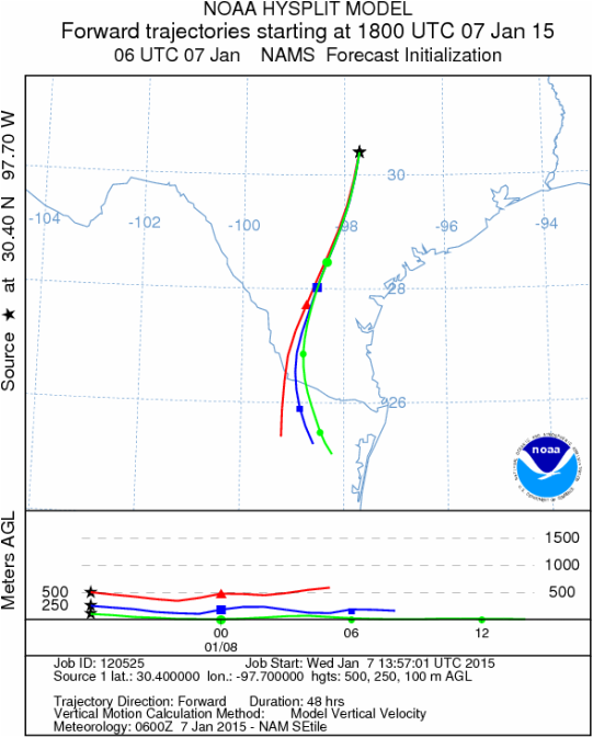
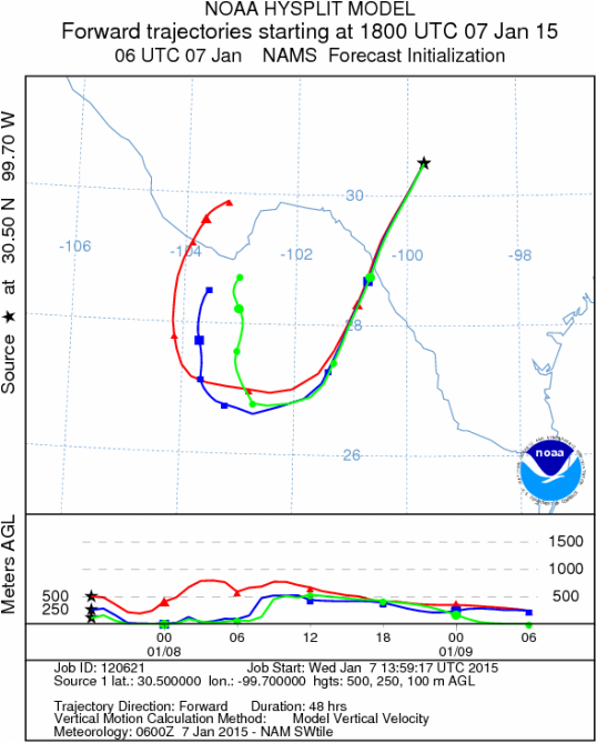
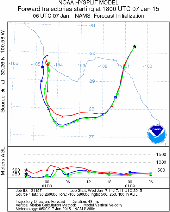
OUTLOOK: ***Moderate to High Threat today and Low Threat Tomorrow. Most tree populations have been exposed to prolonged cold conditions. The exception is the surrounding communities where temperatures got into the 60’s yesterday. Today there will be a 10 to 20 degree cooling in these areas. It usually takes a day or two for significant pollination to occur after very cold events. Today temperatures will get into the 50s in the southernmost regions only. Pollen will be released but in limited areas and we do not expect large amounts region wide. Tomorrow, temperatures will fall back into the 30s and low 40’s where pollination is hindered. Very cold conditions will take over tonight and tomorrow night with lows in the teens across the region. Tomorrow night lows will be in the 20s. The wind trajectories show the atmosphere to be dense and thus any entrained pollen will be traveling close to the ground where impaction often takes it out of the airstream.
Mountain Cedar location(s): Edwards Plateau, Texas.
Regional weather: Wednesday, January 7 – TX/OK: Across the region today conditions will cool once again ahead of cold conditions tomorrow. Skies across Texas will be partly cloudy to mostly sunny. Across the Edwards Plateau temperatures will be in the 30s for a high, today. The southernmost areas along the I-35 corridor will approach the low 50s to the west but remain in the upper 40s through the Austin Metro region and then get colder further north. Dallas is expected to only reach the mid-30s and southern Oklahoma will remain in the 20s today. Throughout the region winds will be strong with sustained levels of 20 to 30 miles per hour from the north. Across the Edwards Plateau will begin at moderate levels but by the afternoon sustained winds at 20 to 30 miles per hour will be boosted by gusts of 40 miles per hour plus. The air will be cold thus most of the trajectories will remain near the ground as it travels. Tonight, low temperatures will drop into the mid-twenties in the warmest areas, such as Austin and San Antonio. The remaining areas will be in the teens. Strong winds will remain blowing across the region creating DANGEROUS wind chill throughout the region. Tomorrow, Texas will see mostly cloudy conditions that will thin to the north with southern Oklahoma having mostly sunny skies. High temperatures will strive to get to the mid-30s in southern Oklahoma, be in the upper 30s in Dallas, and stay in the low 40s across the Edwards Plateau and surrounding communities. Winds will remain at moderately strong conditions with a southerly direction taking over. Tomorrow night mostly cloudy conditions will build in with areas expecting precipitation. In the edge communities to the south there will be a 20% chance of rain or frozen precipitation. There will be a 20% chance of precipitation in the form of snow or sleet across the Dallas/Ft. Worth region. Winds will be from the southwest and south at light to moderate conditions.
Trajectory weather: Air mass trajectories over Texas today will move to the south on very strong northerly winds that will build during the day. Temperatures will be below freezing in southern Oklahoma and remain in the 30s across northern Texas and the Edwards Plateau. The southernmost edge communities will warm into the mid-50s. Winds today will be strong and from the north. Sustained winds above 20 to 25 miles per hour are expected region wide with some areas seeing gusts above 40 miles per hour. Trajectories will move southward across the entire region. Tonight, winds will calm a bit and temperatures will drop into the teens across the Edwards Plateau and remain in the mid- to upper 20s in the edge communities. Tomorrow high temperatures will remain in the low 40s region wide and the overall northerly flow will be replaced by southwesterly winds at light levels across the Plateau. The eastern edge communites will continue with winds from the northeast. Overall wind strength will return to light conditions. Tomorrow night, the edge communities north to the Dallas/Ft.Worth area will see a 20% chance of precipitation in the form of snow or sleet. Winds will remain light mostly from the south.
OUTLOOK: ***Moderate to High Threat today and Low Threat Tomorrow. Most tree populations have been exposed to prolonged cold conditions. The exception is the surrounding communities where temperatures got into the 60’s yesterday. Today there will be a 10 to 20 degree cooling in these areas. It usually takes a day or two for significant pollination to occur after very cold events. Today temperatures will get into the 50s in the southernmost regions only. Pollen will be released but in limited areas and we do not expect large amounts region wide. Tomorrow, temperatures will fall back into the 30s and low 40’s where pollination is hindered. Very cold conditions will take over tonight and tomorrow night with lows in the teens across the region. Tomorrow night lows will be in the 20s. The wind trajectories show the atmosphere to be dense and thus any entrained pollen will be traveling close to the ground where impaction often takes it out of the airstream.
Trajectory
Start (s) (shown by black stars on map):
Austin, TX
Austin, TX
Junction, TX
Sonora, TX
Matrix of sites across the Edwards Plateau (100 meters; 12:00 pm cst)
Prepared by: Estelle Levetin (Faculty of Biological Science, The University of Tulsa, 800 S. Tucker Dr., Tulsa, OK 74104) and Peter K Van de Water (Department of Earth and Environmental Science, California State University Fresno, 2576 East San Ramon Avenue, M/S ST24, Fresno CA 93740-8039). This forecast gives the anticipated future track of released Mountain Cedar pollen, weather conditions over the region and along the forecast pathway, and an estimated time of arrival for various metropolitan areas.Questions: Aerobiology Lab e-mail: [email protected]
Return to ForecastingHome Page
Return to ForecastingHome Page
