|
Metropolitan Area
Oklahoma City Tulsa St. Louis |
Exposure Risk
Low Low Low |
Date Issued: 8 January, 2015
Mountain Cedar location(s): Arbuckle Mountains, OK
Regional weather: Thursday, January 8 – TX/OK: Across the region today conditions will be cold with the warmest areas in the mid-40s across central Texas and the mid-30s in southern Oklahoma. Skies across Texas will be mostly cloudy but thinning to the north with the Dallas/Fort Worth area expecting sunny skies. Temperatures in most areas dipped well below freezing overnight and will take some time to warm. Winds will be from the southwest across the Edwards Plateau and from the south in north Texas and southern Oklahoma. Wind strength will be strong to the north and moderate to light across the rest of the region. The edge communities will begin the day with northeasterly winds but they too will shift this afternoon coming from the south. High temperatures across the entire region are only expected to get into the low 40 degree range. In Oklahoma, the high temperatures will not get out of the 30 degree range. Tonight a chance of precipitation comes into the forecast. The area will remain with cloudy and mostly cloudy conditions. In the edge communities and to the far west there will be a 20% chance of rain, frozen rain, or sleet. Temperatures in the edge communities will stay in the mid- to low 30s. Winds tonight will start from the south but will be overtaken by another push of very cold air from the north for tomorrow. Skies across the region will remain cloudy to mostly cloudy and winds will be from the north to northeast across the region. Tomorrow the high temperatures in Texas are not expected to get above the low 40s in the warmest areas. The Plateau north to Dallas will be in the 30s the entire day and southern Oklahoma should stay below freezing. Across Texas there will be a chance of precipitation with the edge communities showing a 40% chance of rain and/or freezing rain. Winds will be moderate from the north to northeast. Tomorrow night similar conditions will continue, however the chance of freezing rain, sleet will increase with most temperatures expected to bottom out in the twenties across the central and southern areas of the Plateau and out into the edge communities along the I-35 corridor.
Trajectory weather: The air mass over southern Oklahoma today will barely warm throughout the forecast period. Temperatures will only reach the mid-30s in southern Oklahoma today. Winds will be picking up to moderately strong conditions from the south, those winds will begin to shift coming from the north overnight as another push of cold air moves into the region. Overnight cold temperatures will return with readings in the low to mid-twenties. The air will be dense and have very little lift as it travels. Friday, the cold will linger with high temperatures struggling to get to the low-30s under partly cloudy skies. Winds will have switched coming from the north at moderate to light conditions. Overnight, tomorrow, the area will drop back to the teens. The string of cold days and nights should continue to hinder pollination today as conditions remain below freezing. Similar conditions will occur again tomorrow and will keep the area remaining in the low-30 degree range.
OUTLOOK: *** Low Threat today and Low Threat Tomorrow *** poor conditions for pollen release today and tomorrow with temperatures in the mid-30s today and in the low-30 degrees range tomorrow. Over the forecast period winds will begin today from the south but will switch as cold northerly winds from the north take over tonight and into tomorrow. The cold conditions are region wide therefore there is little chance of pollen dispersal and long distance travel.
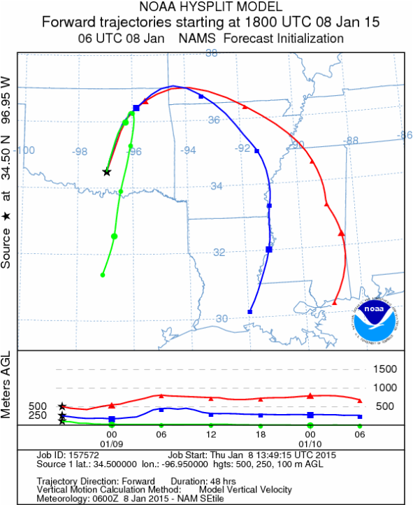
Trajectory Start (s) (shown by black star on map): Davis, OK.
Mountain Cedar location(s): Arbuckle Mountains, OK
Regional weather: Thursday, January 8 – TX/OK: Across the region today conditions will be cold with the warmest areas in the mid-40s across central Texas and the mid-30s in southern Oklahoma. Skies across Texas will be mostly cloudy but thinning to the north with the Dallas/Fort Worth area expecting sunny skies. Temperatures in most areas dipped well below freezing overnight and will take some time to warm. Winds will be from the southwest across the Edwards Plateau and from the south in north Texas and southern Oklahoma. Wind strength will be strong to the north and moderate to light across the rest of the region. The edge communities will begin the day with northeasterly winds but they too will shift this afternoon coming from the south. High temperatures across the entire region are only expected to get into the low 40 degree range. In Oklahoma, the high temperatures will not get out of the 30 degree range. Tonight a chance of precipitation comes into the forecast. The area will remain with cloudy and mostly cloudy conditions. In the edge communities and to the far west there will be a 20% chance of rain, frozen rain, or sleet. Temperatures in the edge communities will stay in the mid- to low 30s. Winds tonight will start from the south but will be overtaken by another push of very cold air from the north for tomorrow. Skies across the region will remain cloudy to mostly cloudy and winds will be from the north to northeast across the region. Tomorrow the high temperatures in Texas are not expected to get above the low 40s in the warmest areas. The Plateau north to Dallas will be in the 30s the entire day and southern Oklahoma should stay below freezing. Across Texas there will be a chance of precipitation with the edge communities showing a 40% chance of rain and/or freezing rain. Winds will be moderate from the north to northeast. Tomorrow night similar conditions will continue, however the chance of freezing rain, sleet will increase with most temperatures expected to bottom out in the twenties across the central and southern areas of the Plateau and out into the edge communities along the I-35 corridor.
Trajectory weather: The air mass over southern Oklahoma today will barely warm throughout the forecast period. Temperatures will only reach the mid-30s in southern Oklahoma today. Winds will be picking up to moderately strong conditions from the south, those winds will begin to shift coming from the north overnight as another push of cold air moves into the region. Overnight cold temperatures will return with readings in the low to mid-twenties. The air will be dense and have very little lift as it travels. Friday, the cold will linger with high temperatures struggling to get to the low-30s under partly cloudy skies. Winds will have switched coming from the north at moderate to light conditions. Overnight, tomorrow, the area will drop back to the teens. The string of cold days and nights should continue to hinder pollination today as conditions remain below freezing. Similar conditions will occur again tomorrow and will keep the area remaining in the low-30 degree range.
OUTLOOK: *** Low Threat today and Low Threat Tomorrow *** poor conditions for pollen release today and tomorrow with temperatures in the mid-30s today and in the low-30 degrees range tomorrow. Over the forecast period winds will begin today from the south but will switch as cold northerly winds from the north take over tonight and into tomorrow. The cold conditions are region wide therefore there is little chance of pollen dispersal and long distance travel.
Trajectory Start (s) (shown by black star on map): Davis, OK.
Prepared by: Estelle Levetin (Faculty of Biological Science, The University of Tulsa, 800 S. Tucker Dr., Tulsa, OK 74104) and Peter K Van de Water (Department of Earth and Environmental Science, California State University Fresno, 2576 East San Ramon Avenue, M/S ST24, Fresno CA 93740-8039). This forecast gives the anticipated future track of released Mountain Cedar pollen, weather conditions over the region and along the forecast pathway, and an estimated time of arrival for various metropolitan areas.
Questions: Aerobiology Lab e-mail: [email protected]
Return to ForecastingHome Page
Questions: Aerobiology Lab e-mail: [email protected]
Return to ForecastingHome Page
