|
Metropolitan Area
Dallas Austin San Antonio |
Exposure Risk
Low High High |
Date Issued: 10 January, 2015
Mountain Cedar location(s): Edwards Plateau, Texas.
Regional weather: Saturday, January 10 and Sunday January 11 – TX/OK: Across the region today conditions will continue to be cold with the warmest areas in the mid-30s. Skies across Texas will be mostly cloudy and there is a chance of precipitation from the Dallas/Ft. Worth metro region southward to San Antonio and beyond. With temperatures only getting into the mid-30s today the chance of frozen precipitation will be a concern. Rain, frozen rain, along with sleet is expected to occur sporadically as the cold air mass over Texas continues to influence the weather picture. Temperatures today across the region will remain in the mid-30s and below. Winds will be light to moderate from the south and southeast to the north in the border areas with Oklahoma as well in areas in the far west. The central Edwards Plateau and surrounding communities will experience light winds from the northeast. Tonight, conditions will worsen with temperatures cooling only into the lower 30s but the chance of precipitation both liquid and frozen will increase. Temperatures across Texas will be in the low 30’s and to the north in Oklahoma in the 20s. Winds across the region, except along the eastern I-35 corridor will be from the south. From Austin to San Antonio a light north easterly flow will continue. Across central Texas the chance of rain will be 50% to 70% tonight. Tomorrow, cloudy skies will remain and a slight chance of rain will continue, especially early. Overall conditions will improve and temperatures will rebound into the 40s and 50s. Areas to the south and west will bounce back into the mid- to upper 50s whereas the eastern edge communities northward into southern Oklahoma will remain in the 40s. Tomorrow night partly cloudy skies will remain with a slight chance of precipitation in north Texas and southern Oklahoma. Low temperatures will remain above freezing, in the 30s, and winds will be from the south to southwest at light conditions
Trajectory weather: Air mass trajectories over Texas today and tomorrow will move to the north on light winds. Areas to the east of the Edwards Plateau will experience periods of flow from the northeast, however the overall flow will move the atmosphere generally northward. The air will continue to be cold and dense thus movement at the lowest levels will continue at ground level. Temperatures will be cold at the ground, in the 30s, thus there should be very little release of pollen during the day. Towards the evening there will be an increased chance of rain showers with temperatures hovering around the freezing mark, thus frozen precipitation tonight is a real possibility. Tomorrow conditions will improve, significantly with warmer temperatures. The western and central Edwards Plateau will reach into the lower 50s, for the first time in a number of days. The eastern edge communities northward all the way into Oklahoma will warm into the mid- to upper 40s. In the edge communities, northward to southern Oklahoma the chance of rain will continue into the morning, but clearing should occur later. Winds will remain light from the south to southwest except for a northeasterly flow along the Plateau edge. Tomorrow night temperatures will drop back into the 30s across the region. There will remain a slight chance of precipitation in northern Texas and southern Oklahoma and winds will remain light and consistent with the overall flow seen during the day.
OUTLOOK: *** Low Threat today and High Threat Tomorrow. The tree populations continue to be exposed to prolonged cold and wet conditions. Today conditions will remain cold and damp with the chance of rain, and/or frozen precipitation increasing towards this evening. The forecast area is not expected to get out of the 30 degree range today or tonight. Precipitation, in whatever form that it falls in will occur across the entire forecast area. Winds will be light to moderate moving from the southeast across the Edwards Plateau. However in the edge communities a northeasterly flow will occur. Tomorrow, the area will warm with much of the southern Plateau and the surrounding communities in reaching the low to mid-50s. There will continue to be a chance of rain in the forecast but the potential for pollen being released, entrained in the atmosphere will be building. We are expected that southern areas may see significant concentrations locally within the areas where trees occur. The dense air and light wind speeds should keep it local and if there are showers they will tend to knock down higher pollen concentrations.
Trajectory Start (s) (shown by black stars on map):
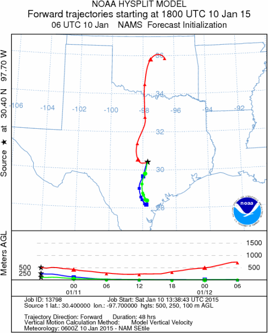
Austin, TX
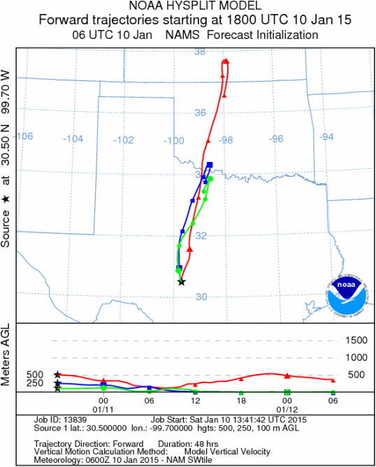
Junction, TX
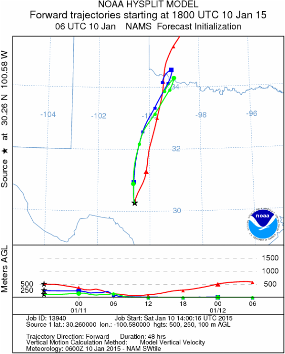
Sonora, TX
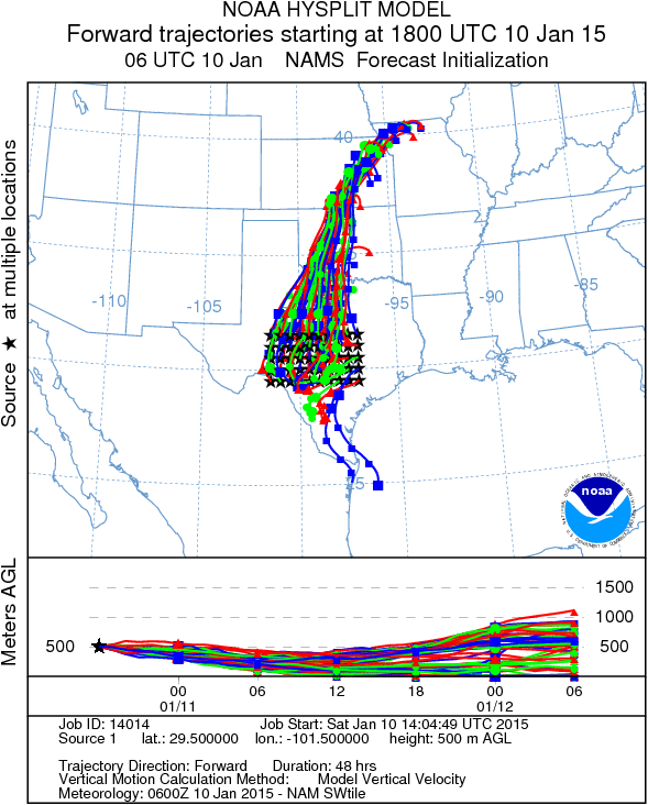
Matrix of sites across the Edwards Plateau (100 meters; 12:00 pm cst)
Prepared by: Estelle Levetin (Faculty of Biological Science, The University of Tulsa, 800 S. Tucker Dr., Tulsa, OK 74104) and Peter K Van de Water (Department of Earth and Environmental Science, California State University Fresno, 2576 East San Ramon Avenue, M/S ST24, Fresno CA 93740-8039). This forecast gives the anticipated future track of released Mountain Cedar pollen, weather conditions over the region and along the forecast pathway, and an estimated time of arrival for various metropolitan areas.Questions: Aerobiology Lab e-mail: [email protected]
Return to ForecastingHome Page
Return to ForecastingHome Page
