|
Metropolitan Area
Oklahoma City Tulsa St. Louis |
Exposure Risk
Low Low Low |
Date Issued: 14 January 2015
Mountain Cedar location(s): Arbuckle Mountains, OK
Regional weather: Wednesday, January 14 – TX/OK: Across the region today conditions will be cool today and then begin to warm up tomorrow. Across the Edwards Plateau and in the surrounding communities cloudy to mostly cloudy conditions will occur. In Austin to San Antonio there will be a slight chance of rain and drizzle. High temperatures will be in the 40s across the forecast area. Winds will be light from the north to northeast. In Southern Oklahoma high temperatures will barely get to 40 degrees today. Winds will be light and variable. Tonight the Edwards Plateau will start the day with cloudy and mostly cloudy skies. Lows over the Plateau will dip into the 20s once again. The surrounding communities will be in the 30s towards the north. North of the Dallas/Ft. Worth metro region temperatures will return to the 20s. Winds will be from the north and northwest at light conditions. Tomorrow the Edwards Plateau will see warming conditions. Partly cloudy conditions early will give way to mostly sunny and clear conditions. For the first time in some time, temperatures will warm into the mid to upper 50s. Winds will be moderate from 5 to 10 miles per hour. In southern Oklahoma high temperatures will be in the lower 50s under sunny skies. Winds will be light and variable. Tomorrow night mostly clear conditions will prevail with mostly clear skies and thus cooling. Most areas will be in the 30s from southern Oklahoma south across portions of the northern Edwards Plateau then southward around the edge of the Plateau. On the Plateau especially towards the west temperature will cool into the mid-20s. Winds will be light and somewhat mixed although most flow will come from the north and northwest.
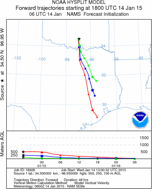
Trajectory weather: Air mass trajectories over southern Oklahoma will move from the north toward the south today, tonight, tomorrow and tomorrow night. The atmosphere will continue to be cool and thus the air will be dense and generally moving from the north towards the south. However throughout the forecast winds will remain light and variable, thus the air will not move very far from the initiation point. Temperatures today will remain in the 40s and tomorrow will be in the 50s for the southern Oklahoma region. There have been a number of cold days stretching back in time, in which little pollen has been recorded. We expect that little pollen will be released today and once the sun goes below the horizon temperatures will fall back into the upper 20s. Tomorrow the air temperature will rise into the 50s and pollen release is expected. Skies will be sunny and temperatures in the lower 50s with light and variable winds. Tomorrow night will bring above freezing conditions. The dominant northerly direction of the atmospheric flow will move any pollen that is entrained towards the south but at light conditions. The colder atmosphere means that most of the trajectories will be at or near the ground surface where entrained pollen often impacts itself against natural and manmade objects further reducing the amount of pollen spread downwind.
OUTLOOK: *** Low Threat today and Moderate conditions Tomorrow. The tree populations continue to be exposed to prolonged cold and wet conditions. Today conditions will remain cold with the high temperature only in the 40 degree range and mostly cloudy skies. Tomorrow temperatures will warm to the lower 50s under sunny skies. Pollen release should begin, however winds will be light and variable. The potential for pollen being released and entrained in the atmosphere will be better tomorrow Today the dense air will move to the south. Any pollen that gets entrained within the atmosphere will be moving at low levels where impaction should cause a majority of it to settle relatively close to the source. Tomorrow will have much better conditions for release and entrainment for travel. Throughout the forecast period winds will be very light and thus will not dominate the process of dispersal downwind.
Trajectory Start (s) (shown by black star on map): Davis, OK.
Mountain Cedar location(s): Arbuckle Mountains, OK
Regional weather: Wednesday, January 14 – TX/OK: Across the region today conditions will be cool today and then begin to warm up tomorrow. Across the Edwards Plateau and in the surrounding communities cloudy to mostly cloudy conditions will occur. In Austin to San Antonio there will be a slight chance of rain and drizzle. High temperatures will be in the 40s across the forecast area. Winds will be light from the north to northeast. In Southern Oklahoma high temperatures will barely get to 40 degrees today. Winds will be light and variable. Tonight the Edwards Plateau will start the day with cloudy and mostly cloudy skies. Lows over the Plateau will dip into the 20s once again. The surrounding communities will be in the 30s towards the north. North of the Dallas/Ft. Worth metro region temperatures will return to the 20s. Winds will be from the north and northwest at light conditions. Tomorrow the Edwards Plateau will see warming conditions. Partly cloudy conditions early will give way to mostly sunny and clear conditions. For the first time in some time, temperatures will warm into the mid to upper 50s. Winds will be moderate from 5 to 10 miles per hour. In southern Oklahoma high temperatures will be in the lower 50s under sunny skies. Winds will be light and variable. Tomorrow night mostly clear conditions will prevail with mostly clear skies and thus cooling. Most areas will be in the 30s from southern Oklahoma south across portions of the northern Edwards Plateau then southward around the edge of the Plateau. On the Plateau especially towards the west temperature will cool into the mid-20s. Winds will be light and somewhat mixed although most flow will come from the north and northwest.
Trajectory weather: Air mass trajectories over southern Oklahoma will move from the north toward the south today, tonight, tomorrow and tomorrow night. The atmosphere will continue to be cool and thus the air will be dense and generally moving from the north towards the south. However throughout the forecast winds will remain light and variable, thus the air will not move very far from the initiation point. Temperatures today will remain in the 40s and tomorrow will be in the 50s for the southern Oklahoma region. There have been a number of cold days stretching back in time, in which little pollen has been recorded. We expect that little pollen will be released today and once the sun goes below the horizon temperatures will fall back into the upper 20s. Tomorrow the air temperature will rise into the 50s and pollen release is expected. Skies will be sunny and temperatures in the lower 50s with light and variable winds. Tomorrow night will bring above freezing conditions. The dominant northerly direction of the atmospheric flow will move any pollen that is entrained towards the south but at light conditions. The colder atmosphere means that most of the trajectories will be at or near the ground surface where entrained pollen often impacts itself against natural and manmade objects further reducing the amount of pollen spread downwind.
OUTLOOK: *** Low Threat today and Moderate conditions Tomorrow. The tree populations continue to be exposed to prolonged cold and wet conditions. Today conditions will remain cold with the high temperature only in the 40 degree range and mostly cloudy skies. Tomorrow temperatures will warm to the lower 50s under sunny skies. Pollen release should begin, however winds will be light and variable. The potential for pollen being released and entrained in the atmosphere will be better tomorrow Today the dense air will move to the south. Any pollen that gets entrained within the atmosphere will be moving at low levels where impaction should cause a majority of it to settle relatively close to the source. Tomorrow will have much better conditions for release and entrainment for travel. Throughout the forecast period winds will be very light and thus will not dominate the process of dispersal downwind.
Trajectory Start (s) (shown by black star on map): Davis, OK.
Prepared by: Estelle Levetin (Faculty of Biological Science, The University of Tulsa, 800 S. Tucker Dr., Tulsa, OK 74104) and Peter K Van de Water (Department of Earth and Environmental Science, California State University Fresno, 2576 East San Ramon Avenue, M/S ST24, Fresno CA 93740-8039). This forecast gives the anticipated future track of released Mountain Cedar pollen, weather conditions over the region and along the forecast pathway, and an estimated time of arrival for various metropolitan areas.
Questions: Aerobiology Lab e-mail: [email protected]
Return to ForecastingHome Page
Questions: Aerobiology Lab e-mail: [email protected]
Return to ForecastingHome Page
