|
Metropolitan Area
Oklahoma City Tulsa St. Louis |
Exposure Risk
Moderate High Moderate |
Date Issued: 16 January 2015
Mountain Cedar location(s): Arbuckle Mountains, OK
Regional weather: Friday, January 16 – TX/OK: Across the region today conditions will be warming with highs expected in the 60 degree range and tomorrow in the 70 degree range. Across the region skies will be sunny but with some clouds building in tonight across the southern Edwards Plateau. Temperatures today will be in the 60s and cool into the 30s tonight. The warmest localities tonight will be along the southern edge of the Edwards Plateau where lows will cool into the lower 40s. Elsewhere tonight’s temperatures will be in the 30’s but it is not expected to freeze. Even to the north in southern Oklahoma the lows will be in the upper 30s tonight. Winds will be from the southwest across and around the Edwards Plateau. Tomorrow sunny skies will once again prevail with temperatures across the southern areas in the 70s. The surrounding communities north toward southern Oklahoma temperatures in the 60s are expected. Winds will be from the southwest to west at moderate conditions. As with today, temperatures will decrease to the north, but the difference between central Texas and north Texas and Oklahoma will only be 10 degrees. Overnight mostly clear conditions will remain with temperatures in the lower 30s in southern Oklahoma and across the southern plateau. In the surrounding communities lows will be in the lower 40s. Tomorrow night winds will be from the north and west, however the westerly component will begin to change with winds coming from the northwest.
Trajectory weather: Air mass trajectories over southern Oklahoma will move from the south to north on light to moderate winds. Temperatures will be in the low 60’s over the entire area and the skies clear for today and tomorrow. Trajectories will be moving northward on light to moderate winds from the south to southwest. The atmosphere will be warming with the dense air becoming more buoyant. Temperatures will top out in the low-60s today. Tomorrow, temperatures will warm slightly with highs expected in the low to mid 60s. The conditions for the next two days are the best that Southern Oklahoma has seen to date for the entrainment and dispersal of pollen. The trajectories will move pollen to the north over western Oklahoma. Southern Oklahoma will remain sunny across the forecast period. There have been a long run of cold days, in which little pollen has been recorded. Today and especially tomorrow, the region will have warmer conditions with readings in the 60s. With the warm conditions the release of pollen should be much more common and with winds in the 5 to 10 miles per hour range some long distance dispersal is expected. Warmer conditions will also result in a more buoyant atmosphere which is also a factor in long distance dispersal.
OUTLOOK: *** Severe Threat today and Severe conditions tomorrow. The tree populations have been exposed to prolonged cold and wet conditions. Today conditions will change with high temperature in low 60 degree range and sunny skies. Tomorrow temperatures will warm to the mid-60s under sunny skies. Pollen release should begin, however winds will be light and variable. The potential for pollen being released and entrained in the atmosphere will be better tomorrow and is expected. Conditions for release and entrainment for travel today and tomorrow will be bolstered by an overall regional flow that will bring entrained pollen from Texas north into the western Oklahoma region and beyond. Conditions for large amounts of pollen in the atmosphere will be building with temperatures expected in the mid 60s and slightly stronger winds .
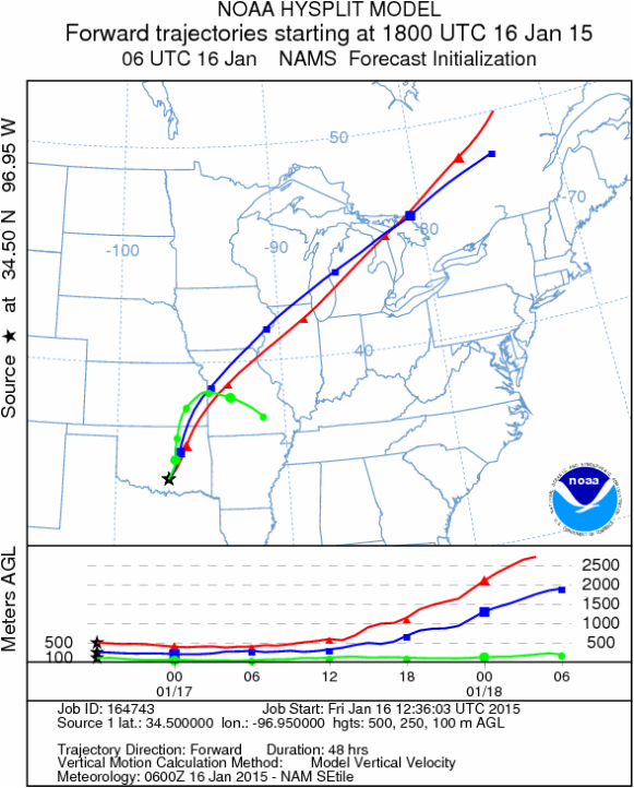
Trajectory Start (s) (shown by black star on map): Davis, OK.
Mountain Cedar location(s): Arbuckle Mountains, OK
Regional weather: Friday, January 16 – TX/OK: Across the region today conditions will be warming with highs expected in the 60 degree range and tomorrow in the 70 degree range. Across the region skies will be sunny but with some clouds building in tonight across the southern Edwards Plateau. Temperatures today will be in the 60s and cool into the 30s tonight. The warmest localities tonight will be along the southern edge of the Edwards Plateau where lows will cool into the lower 40s. Elsewhere tonight’s temperatures will be in the 30’s but it is not expected to freeze. Even to the north in southern Oklahoma the lows will be in the upper 30s tonight. Winds will be from the southwest across and around the Edwards Plateau. Tomorrow sunny skies will once again prevail with temperatures across the southern areas in the 70s. The surrounding communities north toward southern Oklahoma temperatures in the 60s are expected. Winds will be from the southwest to west at moderate conditions. As with today, temperatures will decrease to the north, but the difference between central Texas and north Texas and Oklahoma will only be 10 degrees. Overnight mostly clear conditions will remain with temperatures in the lower 30s in southern Oklahoma and across the southern plateau. In the surrounding communities lows will be in the lower 40s. Tomorrow night winds will be from the north and west, however the westerly component will begin to change with winds coming from the northwest.
Trajectory weather: Air mass trajectories over southern Oklahoma will move from the south to north on light to moderate winds. Temperatures will be in the low 60’s over the entire area and the skies clear for today and tomorrow. Trajectories will be moving northward on light to moderate winds from the south to southwest. The atmosphere will be warming with the dense air becoming more buoyant. Temperatures will top out in the low-60s today. Tomorrow, temperatures will warm slightly with highs expected in the low to mid 60s. The conditions for the next two days are the best that Southern Oklahoma has seen to date for the entrainment and dispersal of pollen. The trajectories will move pollen to the north over western Oklahoma. Southern Oklahoma will remain sunny across the forecast period. There have been a long run of cold days, in which little pollen has been recorded. Today and especially tomorrow, the region will have warmer conditions with readings in the 60s. With the warm conditions the release of pollen should be much more common and with winds in the 5 to 10 miles per hour range some long distance dispersal is expected. Warmer conditions will also result in a more buoyant atmosphere which is also a factor in long distance dispersal.
OUTLOOK: *** Severe Threat today and Severe conditions tomorrow. The tree populations have been exposed to prolonged cold and wet conditions. Today conditions will change with high temperature in low 60 degree range and sunny skies. Tomorrow temperatures will warm to the mid-60s under sunny skies. Pollen release should begin, however winds will be light and variable. The potential for pollen being released and entrained in the atmosphere will be better tomorrow and is expected. Conditions for release and entrainment for travel today and tomorrow will be bolstered by an overall regional flow that will bring entrained pollen from Texas north into the western Oklahoma region and beyond. Conditions for large amounts of pollen in the atmosphere will be building with temperatures expected in the mid 60s and slightly stronger winds .
Trajectory Start (s) (shown by black star on map): Davis, OK.
Prepared by: Estelle Levetin (Faculty of Biological Science, The University of Tulsa, 800 S. Tucker Dr., Tulsa, OK 74104) and Peter K Van de Water (Department of Earth and Environmental Science, California State University Fresno, 2576 East San Ramon Avenue, M/S ST24, Fresno CA 93740-8039). This forecast gives the anticipated future track of released Mountain Cedar pollen, weather conditions over the region and along the forecast pathway, and an estimated time of arrival for various metropolitan areas.
Questions: Aerobiology Lab e-mail: [email protected]
Return to ForecastingHome Page
Questions: Aerobiology Lab e-mail: [email protected]
Return to ForecastingHome Page
