|
Metropolitan Area
Dallas Austin San Antonio |
Exposure Risk
Severe Severe Severe |
Date Issued: 17 January, 2015
Mountain Cedar location(s): Edwards Plateau, Texas.
Regional weather: Saturday, January 17 and Sunday, January 18 – TX/OK: Across the region today conditions will be warm with highs expected in the 60 degree and low 70 degree range under sunny skies. Tomorrow a slight cooling will occur with most areas reaching the 60s. Winds will initially begin from the southwest at light to moderate conditions then switch coming from the north and northwest at light to moderate levels. Overnight skies will be mostly clear with moderate winds from the north and temperatures in the low 30s across the Edwards Plateau and northward into southern Oklahoma. The edge communities along the I-35 corridor will only get down into the lower 40 degree range. Tomorrow sunny to mostly sunny conditions will occur. Temperatures will cool slightly, remaining only in the 60s throughout the area. Winds will remain from the northeast to northwest across the central portion of the forecast area. On the Edwards Plateau to the west and to the north in Oklahoma a southwesterly breeze will begin to build. Tomorrow night will be mostly clear with temperatures in the mid- to upper 30s across most of the Edwards Plateau, northward into southern Oklahoma. The edge communities will only move down into the lower 40s. Winds across the entire forecast area will be from the south at light levels.
Trajectory weather: Air mass trajectories over Texas will move initially from the south and southwest towards the north and northwest on light to moderate conditions. Then overnight a northerly wind will take over pushing most of the trajectories back southward on light to moderate wind flow. Tomorrow the northerly track will be turned once again back so a south to north flow overnight. Conditions will be warm today and slightly cooler tomorrow with high temperatures in the lower 70s across the southern plateau and into the southern edge communities. Tomorrow high temperatures will be in the 60s. The air across the region remains dense at the surface but higher the trajectories move on stronger winds following in general the surface flow. Conditions for release will be very good over the forecast period, however entrainment and long distance travel will be hampered by the overall light winds at the surface.
OUTLOOK: ***Severe Threat today and Severe threat Today and Tomorrow. Today conditions will be very good with high temperature in the 60 degree range and sunny skies. Tomorrow temperatures will warm to the mid-70s under sunny skies. Pollen release should be ongoing, however winds will be light and variable at low levels. The potential for pollen being released and entrained in the atmosphere will be good both days. However, once entrained the dense air at the ground may hamper long distance travel. Today the winds will move towards the north and northeast as most areas will see a southwest wind at light levels. Overnight the trajectories will move towards the south on northerly winds. Tomorrow, southerly winds will eventually take over and tomorrow night the overall flow will once again be from the southwest. The trajectories show little buoyancy and thus entrained pollen will be moving in the lower atmosphere where impaction is common.
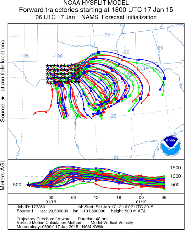
Trajectory
Start (s) (shown by black stars on map):
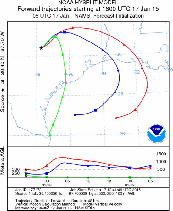
Austin, TX
Austin, TX
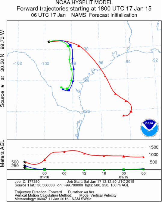
Junction, TX
Sonora, TX
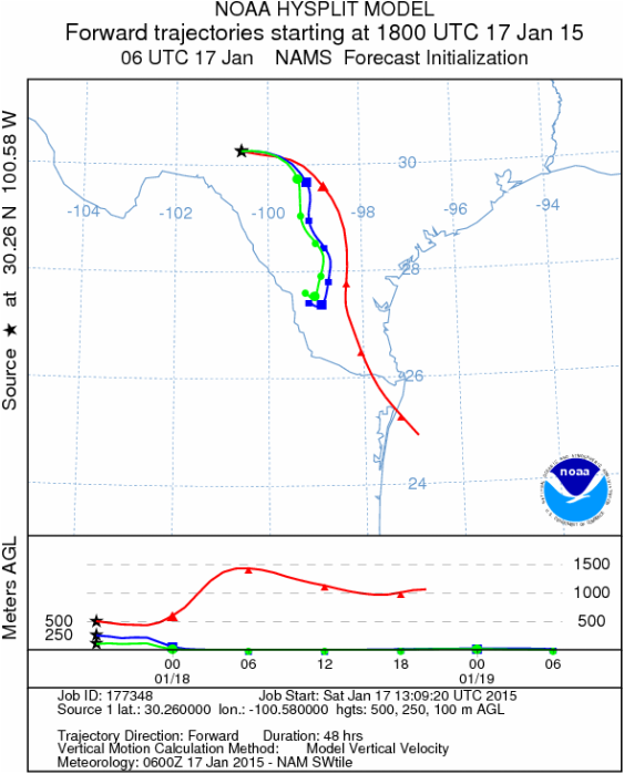
Matrix of sites across the Edwards Plateau (100 meters; 12:00 pm cst)
Prepared by: Estelle Levetin (Faculty of Biological Science, The University of Tulsa, 800 S. Tucker Dr., Tulsa, OK 74104) and Peter K Van de Water (Department of Earth and Environmental Science, California State University Fresno, 2576 East San Ramon Avenue, M/S ST24, Fresno CA 93740-8039). This forecast gives the anticipated future track of released Mountain Cedar pollen, weather conditions over the region and along the forecast pathway, and an estimated time of arrival for various metropolitan areas.Questions: Aerobiology Lab e-mail: [email protected]
Return to ForecastingHome Page
Return to ForecastingHome Page
