|
Metropolitan Area
Oklahoma City Tulsa St. Louis |
Exposure Risk
Moderate Low Low |
Date Issued: 20 January, 2014
Mountain Cedar location(s): Arbuckle Mountains, OK
Regional weather: Tuesday, January 20 – TX/OK: Across the region today conditions will be remain unseasonably warm with highs expected in the 70s with the upper 70s in the edge communities. Northern Texas and southern Oklahoma will be in the mid to upper 60s. Skies will be sunny to mostly sunny and winds will be light from the northeast at 10 to 15 miles per hour. Across the Edwards Plateau sunny conditions will prevail with winds initially from the west and southwest at light conditions then turning in the late afternoon to an overall northeasterly pattern. Tonight partly cloudy skies will build with the edge communities experiencing patchy fog. Low temperatures will be in the 40s with a dominant northeasterly wind at 5 to 10 miles per hour. Tomorrow will see partly cloudy to mostly cloudy conditions. High Temperatures will be in the mid 50 degree range in southern Oklahoma and in the low to mid 60s further south with the warmest areas being in the edge communities. A chance of rain will begin to build to the south and east with patch fog and then an increasing chance of showers overnight. Cloudy skies will remain overnight with rain expected across the area. In southern Oklahoma temperatures will be in the mid to low thirties and thus rain and snow are forecast. To the south in Texas low temperatures are expected in the low 40s with a 80-90% chance of precipitation overnight. Winds will remain from the northeast at 10 to 15 miles per hour.
Trajectory weather: Air mass trajectories over southern Oklahoma will move initially from the northeast towards the southwest on light wind conditions then turn as southwesterly winds blow back towards the northeast. Tonight and tomorrow as well as tomorrow night winds will be from the northeast moving winds towards the southwest. Conditions will be very good today with temperatures in the mid-60s under sunny skies. Tonight, lows will remain above freezing with readings in the mid-30s. Winds will be from the northeast becoming light and variable overnight. Tomorrow changes begin with partly cloudy skies and high temperatures in the mid-50s. Winds will continue from the northeast at 10 miles per hour. Further south, the southwest corner of the Edwards Plateau will see the encroachment of a rain system. By tomorrow night, the region from central Oklahoma southward to the southern Edwards Plateau area will have precipitation with low temperatures in the middle 30s and winds from the northeast at 10 to 15 miles per hour.
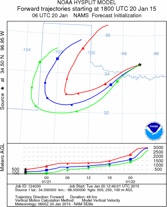
OUTLOOK: *** Severe Threat today and High threat Tomorrow. Today conditions will be very good with high temperature in the 60s under sunny skies. Tomorrow temperatures will cool to the middle 50s, with partly cloudy skies. Pollen release should be continuing, however winds will remain at lower levels with a buoyant atmosphere. The potential for pollen being released and entrained in the atmosphere will be good both days. Once entrained, the pollen will then travel, most likely to the southwest. The current trajectory shows it move southwest then turns towards the northeast. Trajectories later today are expected to show the more southwesterly movement on the predicted northeasterly winds that will continue tonight, tomorrow and tomorrow night.
Trajectory Start (s) (shown by black star on map): Davis, OK.
Mountain Cedar location(s): Arbuckle Mountains, OK
Regional weather: Tuesday, January 20 – TX/OK: Across the region today conditions will be remain unseasonably warm with highs expected in the 70s with the upper 70s in the edge communities. Northern Texas and southern Oklahoma will be in the mid to upper 60s. Skies will be sunny to mostly sunny and winds will be light from the northeast at 10 to 15 miles per hour. Across the Edwards Plateau sunny conditions will prevail with winds initially from the west and southwest at light conditions then turning in the late afternoon to an overall northeasterly pattern. Tonight partly cloudy skies will build with the edge communities experiencing patchy fog. Low temperatures will be in the 40s with a dominant northeasterly wind at 5 to 10 miles per hour. Tomorrow will see partly cloudy to mostly cloudy conditions. High Temperatures will be in the mid 50 degree range in southern Oklahoma and in the low to mid 60s further south with the warmest areas being in the edge communities. A chance of rain will begin to build to the south and east with patch fog and then an increasing chance of showers overnight. Cloudy skies will remain overnight with rain expected across the area. In southern Oklahoma temperatures will be in the mid to low thirties and thus rain and snow are forecast. To the south in Texas low temperatures are expected in the low 40s with a 80-90% chance of precipitation overnight. Winds will remain from the northeast at 10 to 15 miles per hour.
Trajectory weather: Air mass trajectories over southern Oklahoma will move initially from the northeast towards the southwest on light wind conditions then turn as southwesterly winds blow back towards the northeast. Tonight and tomorrow as well as tomorrow night winds will be from the northeast moving winds towards the southwest. Conditions will be very good today with temperatures in the mid-60s under sunny skies. Tonight, lows will remain above freezing with readings in the mid-30s. Winds will be from the northeast becoming light and variable overnight. Tomorrow changes begin with partly cloudy skies and high temperatures in the mid-50s. Winds will continue from the northeast at 10 miles per hour. Further south, the southwest corner of the Edwards Plateau will see the encroachment of a rain system. By tomorrow night, the region from central Oklahoma southward to the southern Edwards Plateau area will have precipitation with low temperatures in the middle 30s and winds from the northeast at 10 to 15 miles per hour.
OUTLOOK: *** Severe Threat today and High threat Tomorrow. Today conditions will be very good with high temperature in the 60s under sunny skies. Tomorrow temperatures will cool to the middle 50s, with partly cloudy skies. Pollen release should be continuing, however winds will remain at lower levels with a buoyant atmosphere. The potential for pollen being released and entrained in the atmosphere will be good both days. Once entrained, the pollen will then travel, most likely to the southwest. The current trajectory shows it move southwest then turns towards the northeast. Trajectories later today are expected to show the more southwesterly movement on the predicted northeasterly winds that will continue tonight, tomorrow and tomorrow night.
Trajectory Start (s) (shown by black star on map): Davis, OK.
Prepared by: Estelle Levetin (Faculty of Biological Science, The University of Tulsa, 800 S. Tucker Dr., Tulsa, OK 74104) and Peter K Van de Water (Department of Earth and Environmental Science, California State University Fresno, 2576 East San Ramon Avenue, M/S ST24, Fresno CA 93740-8039). This forecast gives the anticipated future track of released Mountain Cedar pollen, weather conditions over the region and along the forecast pathway, and an estimated time of arrival for various metropolitan areas.
Questions: Aerobiology Lab e-mail: [email protected]
Return to ForecastingHome Page
Questions: Aerobiology Lab e-mail: [email protected]
Return to ForecastingHome Page
