|
Metropolitan Area
Dallas Austin San Antonio |
Exposure Risk
Low Low Low |
Date Issued: 31 January, 2015
Mountain Cedar location(s): Edwards Plateau, Texas.
Regional weather: Saturday, January 30 and Sunday, February 1 – TX/OK: Across the region today conditions will be cloudy with rain. The rainy conditions will occur today, tonight, tomorrow and finally begin to trail off tomorrow afternoon and evening. Today temperatures will be in the 50s across the region with moderate winds form the southeast. The chance of rain varies from 60% in the Dallas/Ft. Worth area to 100% across the southern Edwards Plateau. In Oklahoma there will be an 80% chance of rain. Tonight rain will continue with temperatures across central Texas in the mid-50s. It will be in the upper 40s in north Texas and mid-to upper 30s in southern Oklahoma. Winds across the area will be from the south to southeast. Tomorrow the chance of precipitation begins to decline, but most areas will have a 40% to 80% chance. Temperatures will be slightly warmer with reading in the mid- to upper- 50s. The edge communities will be in the low to mid-60s. The winds will begin to shift. In the north and in the communities surrounding the Edwards Plateau will remain from the south and southwest. Some areas the winds will be quite gusty. On the Plateau itself, and to the west winds will be from the north and northwest at light to moderate levels. Tomorrow night mostly cloudy skies will begin the evening, but by morning skies will be only partly cloudy. The chance of rain should be more or less gone from the area. Temperatures will drop, hovering around the freezing mark, especially on the Edwards Plateau. Winds will be moderate to strong from the north.
Trajectory weather: Air mass trajectories over the Edwards Plateau will be influenced by the moisture in the atmosphere. High temperatures today will be in the 50s and low 60s with a light to moderate wind from the southeast at 10 to 20 miles per hour. There will be an 60% to 100% chance of rain today and tonight as well as tomorrow. Cloudy skies will bring moisture in from the southeast and south over the forecast period. By tomorrow night the chance of rain will have moved out of the region and drying will ensue at the beginning of the week. With the beginning of regional rain, most of the pollen should be knocked down cleansing the atmosphere. Temperatures will only change a little staying mostly in the 50s until tomorrow night when clear skies will allow temperatures to drop into the 20s and 30s. Conditions for pollen release, entrainment and travel will be very poor, because of precipitation, over the forecast period
OUTLOOK: ***Low Threat today and Low threat Tomorrow. Conditions will be poor for pollen dispersal. Entrainment and downwind travel will be trivial with the wet conditions across the region. High temperatures will remain relatively stable over the next two days with areas in the 50s and just into the 60s in the southernmost communities. Winds will be from the southeast at moderate levels today and tonight. Tomorrow stronger winds will occur to the north of the Edwards Plateau. On the Plateau itself winds will be switching coming out of the north and northwest as the storm system moves to the east.
Trajectory
Start (s) (shown by black stars on map):
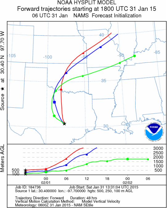
Austin, TX
Austin, TX
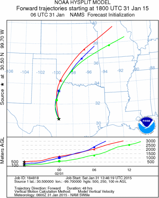
Junction, TX
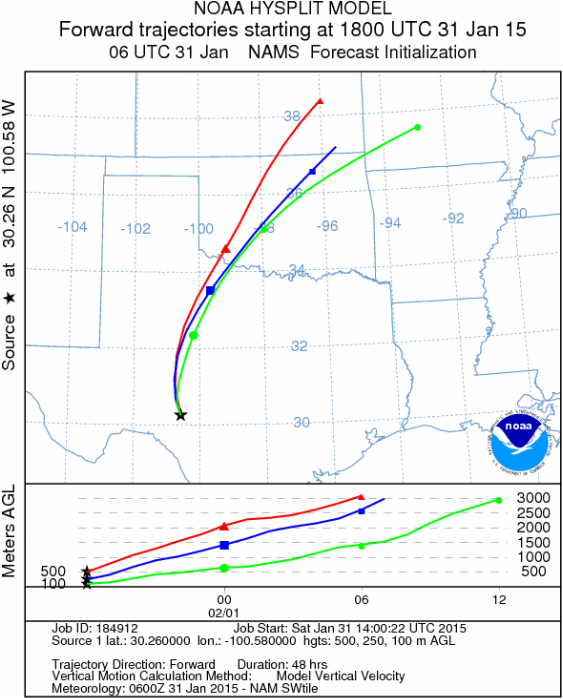
Sonora, TX
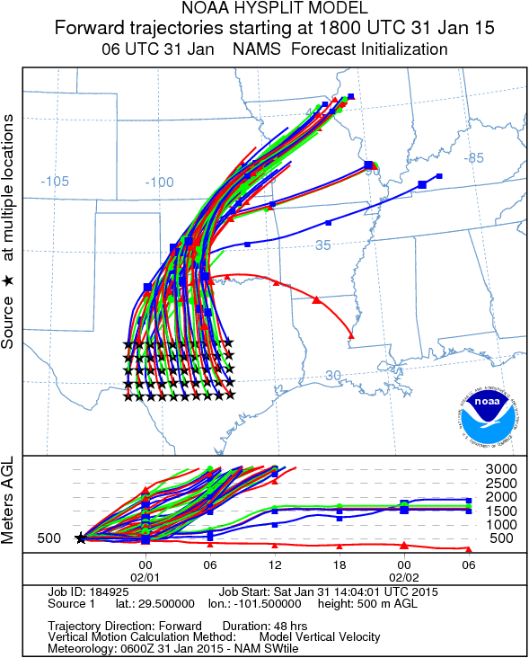
Matrix of sites across the Edwards Plateau (100 meters; 12:00 pm cst)
Prepared by: Estelle Levetin (Faculty of Biological Science, The University of Tulsa, 800 S. Tucker Dr., Tulsa, OK 74104) and Peter K Van de Water (Department of Earth and Environmental Science, California State University Fresno, 2576 East San Ramon Avenue, M/S ST24, Fresno CA 93740-8039). This forecast gives the anticipated future track of released Mountain Cedar pollen, weather conditions over the region and along the forecast pathway, and an estimated time of arrival for various metropolitan areas.Questions: Aerobiology Lab e-mail: [email protected]
Return to ForecastingHome Page
Return to ForecastingHome Page
