|
Metropolitan Area
Oklahoma City Tulsa St. Louis |
Exposure Risk
Low Low Low |
Date Issued: 05 February 2015
Mountain Cedar location(s): Arbuckle Mountains, OK
Regional weather: Monday, Thursday, February 5 – TX/OK: Across the region today conditions will begin with mostly sunny skies to the north and mostly cloudy skies across central Texas. As the day wears on, the southernmost communities will become partly cloudy or clearing skies. Temperatures today will be in the low 40s to the north in the border region between Texas and Oklahoma. Northern Texas in and around the Dallas/Ft. Worth will also be in the low 40s as well. Across the Edwards Plateau temperatures will be in the low 50s. Winds across the region will be from the north at moderate levels of 10 to 15 miles per hour. To the south the winds will begin to switch to a more northeasterly direction. Tonight skies will be clear in Oklahoma with the Edwards Plateau being partly cloudy. Low temperatures will be in the 30s. The Plateau will be in the low to mid 30s whereas the surrounding communities will be in the mid- to upper 30s. Winds will be light and variable with a more southerly flow. Tomorrow the northern areas will be sunny and central Texas mostly sunny. Temperatures are going to climb into the 60s with the western Plateau slightly warmer. Winds will be from the south across most of the region. The western Edwards Plateau will see winds from the southwest. Winds will be at 10 to 15 miles per hour across the region. Tomorrow night from the Dallas/Ft. Worth, towards the west along the western area of the Edwards Plateau mostly clear to clear skies will prevail. The edge communities will have partly cloudy skies. Overnight temperatures will be in the 40s and winds will be from the south and southwest at light to moderate conditions.
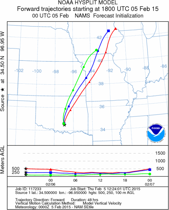
Trajectory weather: Air mass trajectories over the Arbuckle Mountains will be influenced by mostly sunny skies today and tomorrow. Temperatures today will only make it into the low 40 degree range on northerly winds. Tonight skies will be clear and temperatures will drop to the freezing mark on light and variable winds. Tomorrow sunny skies will occur with temperatures rebounding into the low 60s. Winds will be from the south at 10 to 15 miles per hour. Tomorrow night skies will be clear with temperatures in the mi- 40s. Cold conditions today with temperatures in the 40s should restrict pollination. The trajectories from the Arbuckle Mountains move to the slightly southward this morning then are affected by an overall regional southerly flow tomorrow and tomorrow night. Trajectories at ground level show little lift to the atmosphere, therefore it is thought that any pollen released will probably be removed by impaction.
OUTLOOK: *** Low Threat today and Moderate threat Tomorrow. Conditions will be better for pollen release and dispersal tomorrow under warmer conditions. Tomorrow temperatures will be in the mid- 60s with light and moderate winds from the south will move the atmosphere northward. Entrainment and downwind travel will be affected by air density today and tomorrow that will tend to flow at or near ground level where impaction against objects takes pollen out of the airstream. Recently, the pollen total provided by local samplers has begun to show a significant decrease in Juniper pollen indicating the end of the juniper season. As we approach the end of the Juniper season we will no longer provide forecasts this year after Friday February 6th 2015. We thank you for your support of this service.
Trajectory Start (s) (shown by black star on map): Davis, OK.
Mountain Cedar location(s): Arbuckle Mountains, OK
Regional weather: Monday, Thursday, February 5 – TX/OK: Across the region today conditions will begin with mostly sunny skies to the north and mostly cloudy skies across central Texas. As the day wears on, the southernmost communities will become partly cloudy or clearing skies. Temperatures today will be in the low 40s to the north in the border region between Texas and Oklahoma. Northern Texas in and around the Dallas/Ft. Worth will also be in the low 40s as well. Across the Edwards Plateau temperatures will be in the low 50s. Winds across the region will be from the north at moderate levels of 10 to 15 miles per hour. To the south the winds will begin to switch to a more northeasterly direction. Tonight skies will be clear in Oklahoma with the Edwards Plateau being partly cloudy. Low temperatures will be in the 30s. The Plateau will be in the low to mid 30s whereas the surrounding communities will be in the mid- to upper 30s. Winds will be light and variable with a more southerly flow. Tomorrow the northern areas will be sunny and central Texas mostly sunny. Temperatures are going to climb into the 60s with the western Plateau slightly warmer. Winds will be from the south across most of the region. The western Edwards Plateau will see winds from the southwest. Winds will be at 10 to 15 miles per hour across the region. Tomorrow night from the Dallas/Ft. Worth, towards the west along the western area of the Edwards Plateau mostly clear to clear skies will prevail. The edge communities will have partly cloudy skies. Overnight temperatures will be in the 40s and winds will be from the south and southwest at light to moderate conditions.
Trajectory weather: Air mass trajectories over the Arbuckle Mountains will be influenced by mostly sunny skies today and tomorrow. Temperatures today will only make it into the low 40 degree range on northerly winds. Tonight skies will be clear and temperatures will drop to the freezing mark on light and variable winds. Tomorrow sunny skies will occur with temperatures rebounding into the low 60s. Winds will be from the south at 10 to 15 miles per hour. Tomorrow night skies will be clear with temperatures in the mi- 40s. Cold conditions today with temperatures in the 40s should restrict pollination. The trajectories from the Arbuckle Mountains move to the slightly southward this morning then are affected by an overall regional southerly flow tomorrow and tomorrow night. Trajectories at ground level show little lift to the atmosphere, therefore it is thought that any pollen released will probably be removed by impaction.
OUTLOOK: *** Low Threat today and Moderate threat Tomorrow. Conditions will be better for pollen release and dispersal tomorrow under warmer conditions. Tomorrow temperatures will be in the mid- 60s with light and moderate winds from the south will move the atmosphere northward. Entrainment and downwind travel will be affected by air density today and tomorrow that will tend to flow at or near ground level where impaction against objects takes pollen out of the airstream. Recently, the pollen total provided by local samplers has begun to show a significant decrease in Juniper pollen indicating the end of the juniper season. As we approach the end of the Juniper season we will no longer provide forecasts this year after Friday February 6th 2015. We thank you for your support of this service.
Trajectory Start (s) (shown by black star on map): Davis, OK.
Prepared by: Estelle Levetin (Faculty of Biological Science, The University of Tulsa, 800 S. Tucker Dr., Tulsa, OK 74104) and Peter K Van de Water (Department of Earth and Environmental Science, California State University Fresno, 2576 East San Ramon Avenue, M/S ST24, Fresno CA 93740-8039). This forecast gives the anticipated future track of released Mountain Cedar pollen, weather conditions over the region and along the forecast pathway, and an estimated time of arrival for various metropolitan areas.
Questions: Aerobiology Lab e-mail: [email protected]
Return to ForecastingHome Page
Questions: Aerobiology Lab e-mail: [email protected]
Return to ForecastingHome Page
