|
Metropolitan Area
Oklahoma City Tulsa St. Louis |
Exposure Risk
Low Today, High Tomorrow Low Today, High Tomorrow Low Today, Low Tomorrow |
Date Issued: 24 December 2014
Mountain Cedar location(s): Arbuckle Mountains, OK
Regional weather: Wednesday and Thursday, December 24 and 25 – TX/OK: Across the region today skies will be clearing with temperatures warming today and tomorrow. Today, temperatures will be in the 50s across the Edwards Plateau and Texas in general. The eastern edge communities will be in the upper 50s whereas to the west on the Edwards Plateau conditions will be in the lower 50s. Northern Texas into southern Oklahoma high temperatures will be cooler beginning with the upper 40’s in the Dallas/Ft. Worth area, then declining to the mid-40s in Ardmore and low 40s in Oklahoma City. Winds today will be from the northwest at 10 to 15 miles per hour. Tonight, skies will clear and temperatures will fall into the upper 20s to low 30s. Overnight the winds will shift, coming from the southwest at light conditions along the eastern edge of the Edwards Plateau and at 5 to 10 miles per hour on the Plateau itself. Tomorrow, sunny skies will remain with temperatures climbing into the low 60s across the region. Winds will continue to be from the south with very windy conditions building during the day. Gusts to the north in Oklahoma are expected to be upwards of 45 miles per hour, and south over the Edwards Plateau at 15 to 25 miles per hour. Tomorrow night partly cloudy conditions will build back in over the region with warmer overnight conditions. Region wide the nighttime temperatures will only drop into the low 40s over the Plateau and upper 40s along the I-35 corridor. Winds will remain moderate from the south at 15 to 25 miles per hour.
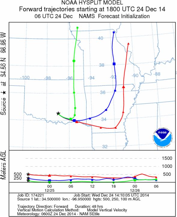
Trajectory weather: Air mass trajectories over southern Oklahoma today will continue to be influenced by the overall flow from the northwest. Areas in southern Oklahoma will struggle to get into the upper 40s and thus pollen release is not expected to be significant. Overnight a front will move through providing a change in the overall flow and wind direction. Tonight winds will be light and variable, tomorrow strong southerly winds will move the overall regional air mass from the south to the north. With the southerly flow warmer conditions will occur and high temperatures will rebound by about 20 degrees with southern Oklahoma returning to the mid-60s. Pollination will be favored and with the southerly winds significant pollen concentrations should effect communities to the north of the tree populations. The overall flow of air will be from the south to the north on Christmas as well as into the evening of Christmas day.
OUTLOOK: *** Low Threat today and SEVERE Threat Tomorrow *** poor conditions for pollen release today with cold conditions and high temperatures only in the mid-40s. Winds across the southern Oklahoma area will be from the northwest at light to moderate levels. Clear skies tonight will drop temperatures at or just below freezing with light to variable winds. Tomorrow, the overall wind patter shifts, coming from the south with moderate to strong conditions. Gusts of 45+ miles per hour are expected in localized areas. With warmer conditions, the trees are expected to release pollen, and with the strong winds, entrainment and travel will move pollen to the north. The areas north of the Arbuckle Mountains will not only be impacted by the southern Oklahoma population but will be the primary travel path of entrained pollen from the larger Texas population.
Trajectory Start (s) (shown by black star on map): Davis, OK.
Mountain Cedar location(s): Arbuckle Mountains, OK
Regional weather: Wednesday and Thursday, December 24 and 25 – TX/OK: Across the region today skies will be clearing with temperatures warming today and tomorrow. Today, temperatures will be in the 50s across the Edwards Plateau and Texas in general. The eastern edge communities will be in the upper 50s whereas to the west on the Edwards Plateau conditions will be in the lower 50s. Northern Texas into southern Oklahoma high temperatures will be cooler beginning with the upper 40’s in the Dallas/Ft. Worth area, then declining to the mid-40s in Ardmore and low 40s in Oklahoma City. Winds today will be from the northwest at 10 to 15 miles per hour. Tonight, skies will clear and temperatures will fall into the upper 20s to low 30s. Overnight the winds will shift, coming from the southwest at light conditions along the eastern edge of the Edwards Plateau and at 5 to 10 miles per hour on the Plateau itself. Tomorrow, sunny skies will remain with temperatures climbing into the low 60s across the region. Winds will continue to be from the south with very windy conditions building during the day. Gusts to the north in Oklahoma are expected to be upwards of 45 miles per hour, and south over the Edwards Plateau at 15 to 25 miles per hour. Tomorrow night partly cloudy conditions will build back in over the region with warmer overnight conditions. Region wide the nighttime temperatures will only drop into the low 40s over the Plateau and upper 40s along the I-35 corridor. Winds will remain moderate from the south at 15 to 25 miles per hour.
Trajectory weather: Air mass trajectories over southern Oklahoma today will continue to be influenced by the overall flow from the northwest. Areas in southern Oklahoma will struggle to get into the upper 40s and thus pollen release is not expected to be significant. Overnight a front will move through providing a change in the overall flow and wind direction. Tonight winds will be light and variable, tomorrow strong southerly winds will move the overall regional air mass from the south to the north. With the southerly flow warmer conditions will occur and high temperatures will rebound by about 20 degrees with southern Oklahoma returning to the mid-60s. Pollination will be favored and with the southerly winds significant pollen concentrations should effect communities to the north of the tree populations. The overall flow of air will be from the south to the north on Christmas as well as into the evening of Christmas day.
OUTLOOK: *** Low Threat today and SEVERE Threat Tomorrow *** poor conditions for pollen release today with cold conditions and high temperatures only in the mid-40s. Winds across the southern Oklahoma area will be from the northwest at light to moderate levels. Clear skies tonight will drop temperatures at or just below freezing with light to variable winds. Tomorrow, the overall wind patter shifts, coming from the south with moderate to strong conditions. Gusts of 45+ miles per hour are expected in localized areas. With warmer conditions, the trees are expected to release pollen, and with the strong winds, entrainment and travel will move pollen to the north. The areas north of the Arbuckle Mountains will not only be impacted by the southern Oklahoma population but will be the primary travel path of entrained pollen from the larger Texas population.
Trajectory Start (s) (shown by black star on map): Davis, OK.
Prepared by: Estelle Levetin (Faculty of Biological Science, The University of Tulsa, 800 S. Tucker Dr., Tulsa, OK 74104) and Peter K Van de Water (Department of Earth and Environmental Science, California State University Fresno, 2576 East San Ramon Avenue, M/S ST24, Fresno CA 93740-8039). This forecast gives the anticipated future track of released Mountain Cedar pollen, weather conditions over the region and along the forecast pathway, and an estimated time of arrival for various metropolitan areas.
Questions: Aerobiology Lab e-mail: [email protected]
Return to ForecastingHome Page
Questions: Aerobiology Lab e-mail: [email protected]
Return to ForecastingHome Page
