|
Metropolitan Area
Oklahoma City Tulsa St. Louis |
Exposure Risk
Severe Severe High |
Date Issued: 26 December 2014
Mountain Cedar location(s): Arbuckle Mountains, OK
Regional weather: Friday, December 26 – TX/OK: Across the region today skies will start as mostly cloudy to partly cloudy, but later clearing across the Edwards Plateau. In the communities surrounding the Plateau mostly cloudy to partly cloudy conditions will remain. In the Dallas/Ft. Worth region north into Oklahoma there will be a 20% chance of precipitation. This morning the areas surrounding the Edwards Plateau may experience patchy drizzle. Temperatures across the region will be in the mid- to upper 60s on winds from the south at moderate levels (10 to 15 mph). In northern Texas and Southern Oklahoma, temperatures will be cooler, in the mid-50s to the north and low 60s in the Texas/Oklahoma border region. Tonight, across the region winds begin to shift from today’s southerly flow to a northwesterly and then northerly flow. With the change in winds, colder conditions move south across the region. Tonight there will be an increasing chance of showers, with the greatest potential being in the north but only at ~40% chance of precipitation. Temperatures will be in the 40s and 50s in the communities surrounding the Edwards Plateau. On the Plateau lows will drop into the low 40s to mid-30s. Tomorrow, cloudy conditions will remain with a chance of showers and occasional thunderstorms. High temperatures will reach the upper 50’s in the edge communities, but on the Edwards Plateau and across northern Texas and southern Oklahoma high temperatures will only be in the 40s. Winds will be from the north at moderate conditions ranging from 10 to 20 miles per hour. The edge communities with their canyons will be areas with gusty conditions. Tomorrow night mostly cloudy conditions will remain across the Edwards Plateau region with low temperatures in the 30s in most areas. However, to the north and the far west expect lows into the mid- to upper 20s.
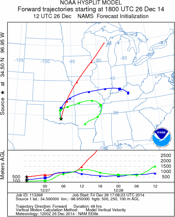
Trajectory weather: Air mass trajectories over the Arbuckle Mountains today will continue to be influenced by the overall flow from the south and relatively warm conditions. Temperatures in southern Oklahoma will be in the low 60s today with mostly cloudy conditions. Areas in northern Texas, such as the Dallas/Ft. Worth metro region will also reach into the mid-60s but the general region there will be a 20% chance of precipitation. Tonight winds will begin to shift to a northerly flow bringing cooler conditions across the region and increasing the chance of precipitation in the area. The dominant southerly flow today will push winds to the north-northeast taking the wind trajectories over Oklahoma, Kansas and Missouri, towards the Great Lakes. Conditions across northern Texas and Southern Oklahoma will be very good for dispersal, entrainment and downwind movement. Areas to the north and northeast are susceptible to long distance transport of Ashe Juniper pollen.
OUTLOOK: *** SEVERE Threat today and Low Threat Tomorrow *** good conditions for pollen release today with warm temperatures in the 60s across the region. Winds will be from the south at light to moderate levels, moving north to northeast. Across southern Oklahoma, temperatures will be in the 60s today with cloudy skies and a chance of precipitation. Clouds will build tonight and winds will begin to shift, coming from the northwest by tomorrow. Tomorrow, the overall wind pattern shifts, coming from the north starting with moderate conditions but building during the afternoon. With warmer conditions today, the trees are expected to release pollen, and with the strong winds, entrainment and travel will move pollen to the north/northeast. Cold conditions tomorrow will see highs in the 40s thus restricting pollination and entrainment.
Trajectory Start (s) (shown by black star on map): Davis, OK.
Mountain Cedar location(s): Arbuckle Mountains, OK
Regional weather: Friday, December 26 – TX/OK: Across the region today skies will start as mostly cloudy to partly cloudy, but later clearing across the Edwards Plateau. In the communities surrounding the Plateau mostly cloudy to partly cloudy conditions will remain. In the Dallas/Ft. Worth region north into Oklahoma there will be a 20% chance of precipitation. This morning the areas surrounding the Edwards Plateau may experience patchy drizzle. Temperatures across the region will be in the mid- to upper 60s on winds from the south at moderate levels (10 to 15 mph). In northern Texas and Southern Oklahoma, temperatures will be cooler, in the mid-50s to the north and low 60s in the Texas/Oklahoma border region. Tonight, across the region winds begin to shift from today’s southerly flow to a northwesterly and then northerly flow. With the change in winds, colder conditions move south across the region. Tonight there will be an increasing chance of showers, with the greatest potential being in the north but only at ~40% chance of precipitation. Temperatures will be in the 40s and 50s in the communities surrounding the Edwards Plateau. On the Plateau lows will drop into the low 40s to mid-30s. Tomorrow, cloudy conditions will remain with a chance of showers and occasional thunderstorms. High temperatures will reach the upper 50’s in the edge communities, but on the Edwards Plateau and across northern Texas and southern Oklahoma high temperatures will only be in the 40s. Winds will be from the north at moderate conditions ranging from 10 to 20 miles per hour. The edge communities with their canyons will be areas with gusty conditions. Tomorrow night mostly cloudy conditions will remain across the Edwards Plateau region with low temperatures in the 30s in most areas. However, to the north and the far west expect lows into the mid- to upper 20s.
Trajectory weather: Air mass trajectories over the Arbuckle Mountains today will continue to be influenced by the overall flow from the south and relatively warm conditions. Temperatures in southern Oklahoma will be in the low 60s today with mostly cloudy conditions. Areas in northern Texas, such as the Dallas/Ft. Worth metro region will also reach into the mid-60s but the general region there will be a 20% chance of precipitation. Tonight winds will begin to shift to a northerly flow bringing cooler conditions across the region and increasing the chance of precipitation in the area. The dominant southerly flow today will push winds to the north-northeast taking the wind trajectories over Oklahoma, Kansas and Missouri, towards the Great Lakes. Conditions across northern Texas and Southern Oklahoma will be very good for dispersal, entrainment and downwind movement. Areas to the north and northeast are susceptible to long distance transport of Ashe Juniper pollen.
OUTLOOK: *** SEVERE Threat today and Low Threat Tomorrow *** good conditions for pollen release today with warm temperatures in the 60s across the region. Winds will be from the south at light to moderate levels, moving north to northeast. Across southern Oklahoma, temperatures will be in the 60s today with cloudy skies and a chance of precipitation. Clouds will build tonight and winds will begin to shift, coming from the northwest by tomorrow. Tomorrow, the overall wind pattern shifts, coming from the north starting with moderate conditions but building during the afternoon. With warmer conditions today, the trees are expected to release pollen, and with the strong winds, entrainment and travel will move pollen to the north/northeast. Cold conditions tomorrow will see highs in the 40s thus restricting pollination and entrainment.
Trajectory Start (s) (shown by black star on map): Davis, OK.
Prepared by: Estelle Levetin (Faculty of Biological Science, The University of Tulsa, 800 S. Tucker Dr., Tulsa, OK 74104) and Peter K Van de Water (Department of Earth and Environmental Science, California State University Fresno, 2576 East San Ramon Avenue, M/S ST24, Fresno CA 93740-8039). This forecast gives the anticipated future track of released Mountain Cedar pollen, weather conditions over the region and along the forecast pathway, and an estimated time of arrival for various metropolitan areas.
Questions: Aerobiology Lab e-mail: [email protected]
Return to ForecastingHome Page
Questions: Aerobiology Lab e-mail: [email protected]
Return to ForecastingHome Page
