|
Metropolitan Area
Oklahoma City Tulsa St. Louis |
Exposure Risk
Low Low Low |
Date Issued: 30 December 2014
Mountain Cedar location(s): Arbuckle Mountains, OK
Regional weather: Monday, December 30 – TX/OK: Across the region today skies will be cloudy to mostly cloudy. However, the Dallas/ Ft. Worth region may see some sun breaks. Temperatures will be cool to cold with the warmest temperatures occurring across the southern Edwards Plateau edge communities. In those areas today’s high may reach the mid 50’s. Across the Edwards Plateau high temperatures will struggle to get out of the mid- 40s to upper 30s. Winds across the region will be from the northeast at light to moderate levels (10 to 15 miles per hour). Temperatures will be colder to the north with the north Texas/Oklahoma border region struggling to get to 40 degrees. To the west and south there will be a 40% chance of frozen rain in San Angelo and 20% chance in Sonora. Overnight those percentages climb to greater than 40% with the chance of frozen precipitation spreading north and east into the central Edwards Plateau area and south into the San Antonio metro region. Low temperatures across the region will be in the 20s on the Plateau and mid to low 30’s in the edge communities. Winds will remain from the northeast at moderate conditions (15 to 20 miles per hour). Tomorrow, cold conditions will remain as will the chance of precipitation to the south. In Southern Oklahoma temperatures will remain in the low 30s. Similarly, high temperatures on the Edwards Plateau will also be in the low 30s and mid 30s in the surrounding communities. The chance of frozen rain and sleet will remain across the southern and western portions of the Edwards Plateau, at 30%. A 20% chance will extend east to the Austin area. Winds will remain at moderate conditions from the northeast but with gusts of 20 to 25 miles per hour. Tomorrow night conditions will remain cold with an increasing chance of frozen precipitation as freezing rain and sleet. Temperatures will remain in the 20s across the Plateau and in the low 30s in the surrounding areas.
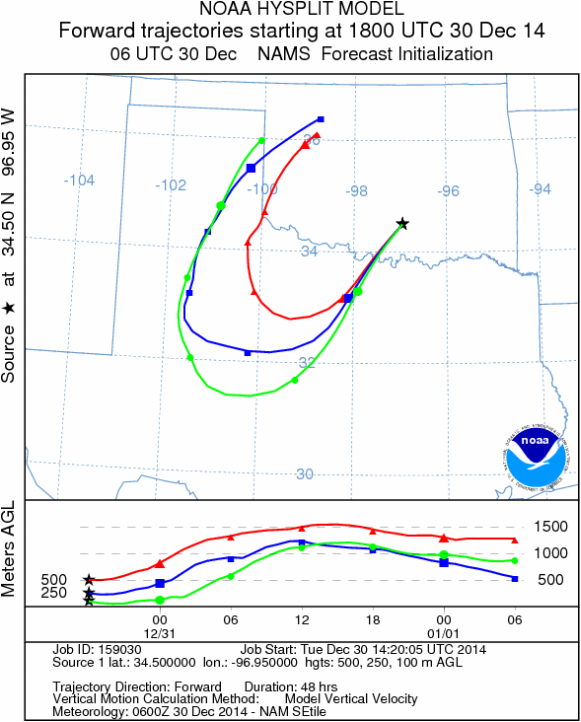
Trajectory weather: Air mass trajectories over southern Oklahoma today will be influenced by cool conditions becoming cold tonight, tomorrow, and tomorrow night. Air flow today will be from the northeast at light to moderate wind strength. Temperatures across southern Oklahoma will be in the low 40s for the high today. Tonight mostly cloudy skies will remain and lows are expected to be close to 20 degrees. Tomorrow conditions will remain cold with the high expected to only reach the low 30s. Cold conditions will not be conducive for pollination and thus we do not expect there to be pollen in the atmosphere. There will be a dominant northeasterly flow, however, as the trajectories move westward they will encounter a blocking pattern causing the flow to eventually begin to move northward over western Texas.
OUTLOOK: *** Low Threat today and Low Threat Tomorrow *** poor conditions for pollen release today and tomorrow with temperatures in the low 40s today and in the 30s tomorrow. Starting tonight, winds will be from the northeast at moderate levels. Tomorrow, cold conditions will continue. In southern Oklahoma high temperatures today and tomorrow will struggle to get close to conditions that are conducive to pollen release. This cold conditions are region wide with a chance of both freezing rain and sleet further south across central Texas.
Trajectory Start (s) (shown by black star on map): Davis, OK.
Mountain Cedar location(s): Arbuckle Mountains, OK
Regional weather: Monday, December 30 – TX/OK: Across the region today skies will be cloudy to mostly cloudy. However, the Dallas/ Ft. Worth region may see some sun breaks. Temperatures will be cool to cold with the warmest temperatures occurring across the southern Edwards Plateau edge communities. In those areas today’s high may reach the mid 50’s. Across the Edwards Plateau high temperatures will struggle to get out of the mid- 40s to upper 30s. Winds across the region will be from the northeast at light to moderate levels (10 to 15 miles per hour). Temperatures will be colder to the north with the north Texas/Oklahoma border region struggling to get to 40 degrees. To the west and south there will be a 40% chance of frozen rain in San Angelo and 20% chance in Sonora. Overnight those percentages climb to greater than 40% with the chance of frozen precipitation spreading north and east into the central Edwards Plateau area and south into the San Antonio metro region. Low temperatures across the region will be in the 20s on the Plateau and mid to low 30’s in the edge communities. Winds will remain from the northeast at moderate conditions (15 to 20 miles per hour). Tomorrow, cold conditions will remain as will the chance of precipitation to the south. In Southern Oklahoma temperatures will remain in the low 30s. Similarly, high temperatures on the Edwards Plateau will also be in the low 30s and mid 30s in the surrounding communities. The chance of frozen rain and sleet will remain across the southern and western portions of the Edwards Plateau, at 30%. A 20% chance will extend east to the Austin area. Winds will remain at moderate conditions from the northeast but with gusts of 20 to 25 miles per hour. Tomorrow night conditions will remain cold with an increasing chance of frozen precipitation as freezing rain and sleet. Temperatures will remain in the 20s across the Plateau and in the low 30s in the surrounding areas.
Trajectory weather: Air mass trajectories over southern Oklahoma today will be influenced by cool conditions becoming cold tonight, tomorrow, and tomorrow night. Air flow today will be from the northeast at light to moderate wind strength. Temperatures across southern Oklahoma will be in the low 40s for the high today. Tonight mostly cloudy skies will remain and lows are expected to be close to 20 degrees. Tomorrow conditions will remain cold with the high expected to only reach the low 30s. Cold conditions will not be conducive for pollination and thus we do not expect there to be pollen in the atmosphere. There will be a dominant northeasterly flow, however, as the trajectories move westward they will encounter a blocking pattern causing the flow to eventually begin to move northward over western Texas.
OUTLOOK: *** Low Threat today and Low Threat Tomorrow *** poor conditions for pollen release today and tomorrow with temperatures in the low 40s today and in the 30s tomorrow. Starting tonight, winds will be from the northeast at moderate levels. Tomorrow, cold conditions will continue. In southern Oklahoma high temperatures today and tomorrow will struggle to get close to conditions that are conducive to pollen release. This cold conditions are region wide with a chance of both freezing rain and sleet further south across central Texas.
Trajectory Start (s) (shown by black star on map): Davis, OK.
Prepared by: Estelle Levetin (Faculty of Biological Science, The University of Tulsa, 800 S. Tucker Dr., Tulsa, OK 74104) and Peter K Van de Water (Department of Earth and Environmental Science, California State University Fresno, 2576 East San Ramon Avenue, M/S ST24, Fresno CA 93740-8039). This forecast gives the anticipated future track of released Mountain Cedar pollen, weather conditions over the region and along the forecast pathway, and an estimated time of arrival for various metropolitan areas.
Questions: Aerobiology Lab e-mail: [email protected]
Return to ForecastingHome Page
Questions: Aerobiology Lab e-mail: [email protected]
Return to ForecastingHome Page
