|
Metropolitan Area
Dallas Austin San Antonio |
Exposure Risk
Low Moderate Moderate |
Date Issued: 30 December, 2014
Mountain Cedar location(s): Edwards Plateau, Texas.
Regional weather: Monday, December 30 – TX/OK: Across the region today skies will be cloudy to mostly cloudy. However, the Dallas/ Ft. Worth region may see some sun breaks. Temperatures will be cool to cold with the warmest temperatures occurring across the southern Edwards Plateau edge communities. In those areas today’s high may reach the mid 50’s. Across the Edwards Plateau high temperatures will struggle to get out of the mid- 40s to upper 30s. Winds across the region will be from the northeast at light to moderate levels (10 to 15 miles per hour). Temperatures will be colder to the north with the north Texas/Oklahoma border region struggling to get to 40 degrees. To the west and south there will be a 40% chance of frozen rain in San Angelo and 20% chance in Sonora. Overnight those percentages climb to greater than 40% with the chance of frozen precipitation spreading north and east into the central Edwards Plateau area and south into the San Antonio metro region. Low temperatures across the region will be in the 20s on the Plateau and mid to low 30’s in the edge communities. Winds will remain from the northeast at moderate conditions (15 to 20 miles per hour). Tomorrow, cold conditions will remain as will the chance of precipitation to the south. In Southern Oklahoma temperatures will remain in the low 30s. Similarly, high temperatures on the Edwards Plateau will also be in the low 30s and mid 30s in the surrounding communities. The chance of frozen rain and sleet will remain across the southern and western portions of the Edwards Plateau, at 30%. A 20% chance will extend east to the Austin area. Winds will remain at moderate conditions from the northeast but with gusts of 20 to 25 miles per hour. Tomorrow night conditions will remain cold with an increasing chance of frozen precipitation as freezing rain and sleet. Temperatures will remain in the 20s across the Plateau and in the low 30s in the surrounding areas.
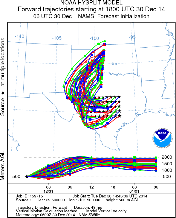
Trajectory weather: Air mass trajectories over central Texas will be influenced by cold conditions across the region becoming colder tonight, tomorrow, and tomorrow night. Air flow today will be from the northeast at light to moderate wind strength. Temperatures across the Edwards Plateau will be in the mid to low 40s, even the upper 30s for the high today. In the edge communities temperatures will get into the low 50s. To the west there will be an increasing chance of freezing rain as well as sleet. Tonight mostly cloudy skies will remain and lows are expected to be in the 20s across the Plateau. The edge communities will be in the mid to upper 30s. Across the Edwards Plateau and moving into the surrounding communities the chance of freezing rain as well as sleet will be increasing. Winds will remain from the northeast at moderate conditions. Tomorrow conditions will remain cold with the high expected to only reach the 30s throughout. The chance of freezing rain and sleet will extend across central Texas. Cold conditions isnot be conducive for pollination. Today there may be release in the surrounding communities as they will reach into the 50s, however the rest of the areas to the west will see significantly reduced amounts being released. Colder conditions tomorrow should result in even less pollen entrained in the atmosphere. In addition, areas with freezing rain and sleet will seal off those cones that would open and release pollen into their surroundings. Cold conditions along with the chance of precipitation will remain overnight tomorrow with cold conditions remaining and the chance of sleet and freezing rain.
OUTLOOK: ****** Moderate Threat today and Poor Threat Tomorrow *** Poor conditions for pollen release today with cold temperatures in all of the forecast area except the communities surrounding the Edwards Plateau. Some pollen may be released from these areas but should be pushed back towards the Edwards Plateau. Temperatures today will get into the low 50s in the surrounding communities and those areas will be the warm spots. Winds will be from the northeast at light to moderate conditions today and will travel towards the west. They will eventually move northward as they encounter a mass of cold air over the southern Rocky Mountains. A chance of precipitation will build, starting to the southwest today and tonight leading to increasing percentages tomorrow and tomorrow night. With the cold conditions at the ground much of this moisture will fall as frozen rain and sleet making for dangerous conditions on the roads and highways. Because of the cold conditions and frozen precipitation we expect little pollination and environmental conditions that will remove and entrained pollen relatively quickly. For those reasons we have moderate conditions today devolving into poor conditions tonight tomorrow, and tomorrow night.
Mountain Cedar location(s): Edwards Plateau, Texas.
Regional weather: Monday, December 30 – TX/OK: Across the region today skies will be cloudy to mostly cloudy. However, the Dallas/ Ft. Worth region may see some sun breaks. Temperatures will be cool to cold with the warmest temperatures occurring across the southern Edwards Plateau edge communities. In those areas today’s high may reach the mid 50’s. Across the Edwards Plateau high temperatures will struggle to get out of the mid- 40s to upper 30s. Winds across the region will be from the northeast at light to moderate levels (10 to 15 miles per hour). Temperatures will be colder to the north with the north Texas/Oklahoma border region struggling to get to 40 degrees. To the west and south there will be a 40% chance of frozen rain in San Angelo and 20% chance in Sonora. Overnight those percentages climb to greater than 40% with the chance of frozen precipitation spreading north and east into the central Edwards Plateau area and south into the San Antonio metro region. Low temperatures across the region will be in the 20s on the Plateau and mid to low 30’s in the edge communities. Winds will remain from the northeast at moderate conditions (15 to 20 miles per hour). Tomorrow, cold conditions will remain as will the chance of precipitation to the south. In Southern Oklahoma temperatures will remain in the low 30s. Similarly, high temperatures on the Edwards Plateau will also be in the low 30s and mid 30s in the surrounding communities. The chance of frozen rain and sleet will remain across the southern and western portions of the Edwards Plateau, at 30%. A 20% chance will extend east to the Austin area. Winds will remain at moderate conditions from the northeast but with gusts of 20 to 25 miles per hour. Tomorrow night conditions will remain cold with an increasing chance of frozen precipitation as freezing rain and sleet. Temperatures will remain in the 20s across the Plateau and in the low 30s in the surrounding areas.
Trajectory weather: Air mass trajectories over central Texas will be influenced by cold conditions across the region becoming colder tonight, tomorrow, and tomorrow night. Air flow today will be from the northeast at light to moderate wind strength. Temperatures across the Edwards Plateau will be in the mid to low 40s, even the upper 30s for the high today. In the edge communities temperatures will get into the low 50s. To the west there will be an increasing chance of freezing rain as well as sleet. Tonight mostly cloudy skies will remain and lows are expected to be in the 20s across the Plateau. The edge communities will be in the mid to upper 30s. Across the Edwards Plateau and moving into the surrounding communities the chance of freezing rain as well as sleet will be increasing. Winds will remain from the northeast at moderate conditions. Tomorrow conditions will remain cold with the high expected to only reach the 30s throughout. The chance of freezing rain and sleet will extend across central Texas. Cold conditions isnot be conducive for pollination. Today there may be release in the surrounding communities as they will reach into the 50s, however the rest of the areas to the west will see significantly reduced amounts being released. Colder conditions tomorrow should result in even less pollen entrained in the atmosphere. In addition, areas with freezing rain and sleet will seal off those cones that would open and release pollen into their surroundings. Cold conditions along with the chance of precipitation will remain overnight tomorrow with cold conditions remaining and the chance of sleet and freezing rain.
OUTLOOK: ****** Moderate Threat today and Poor Threat Tomorrow *** Poor conditions for pollen release today with cold temperatures in all of the forecast area except the communities surrounding the Edwards Plateau. Some pollen may be released from these areas but should be pushed back towards the Edwards Plateau. Temperatures today will get into the low 50s in the surrounding communities and those areas will be the warm spots. Winds will be from the northeast at light to moderate conditions today and will travel towards the west. They will eventually move northward as they encounter a mass of cold air over the southern Rocky Mountains. A chance of precipitation will build, starting to the southwest today and tonight leading to increasing percentages tomorrow and tomorrow night. With the cold conditions at the ground much of this moisture will fall as frozen rain and sleet making for dangerous conditions on the roads and highways. Because of the cold conditions and frozen precipitation we expect little pollination and environmental conditions that will remove and entrained pollen relatively quickly. For those reasons we have moderate conditions today devolving into poor conditions tonight tomorrow, and tomorrow night.
Trajectory Start (s) (shown by black stars on map):
Austin, TX
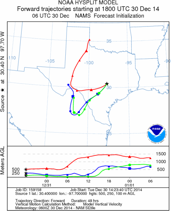
Junction, TX

Sonora, TX
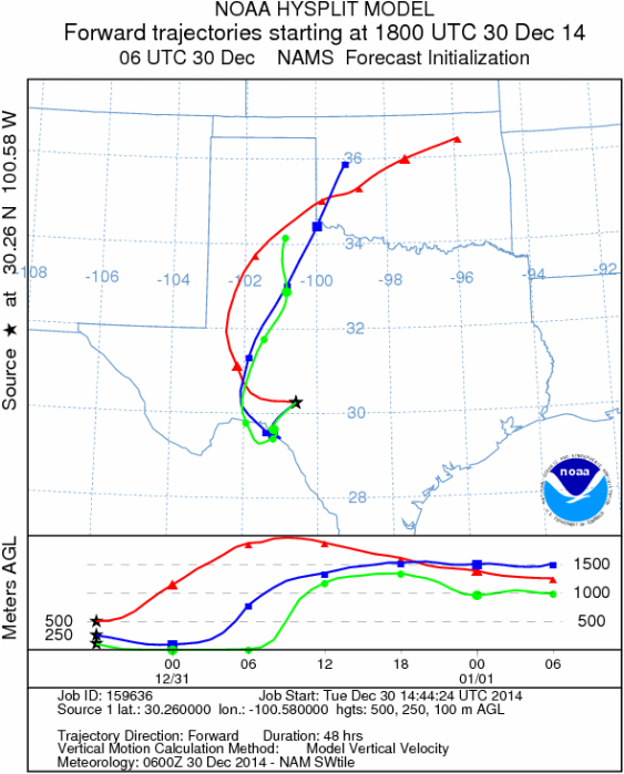
Matrix of sites across the Edwards Plateau (100 meters; 12:00 pm cst)
Prepared by: Estelle Levetin (Faculty of Biological Science, The University of Tulsa, 800 S. Tucker Dr., Tulsa, OK 74104) and Peter K Van de Water (Department of Earth and Environmental Science, California State University Fresno, 2576 East San Ramon Avenue, M/S ST24, Fresno CA 93740-8039). This forecast gives the anticipated future track of released Mountain Cedar pollen, weather conditions over the region and along the forecast pathway, and an estimated time of arrival for various metropolitan areas.Questions: Aerobiology Lab e-mail: [email protected]
Return to ForecastingHome Page
Return to ForecastingHome Page
