|
Metropolitan Area
Dallas Austin San Antonio |
Exposure Risk
Low Moderate Moderate |
Date Issued: 3 January, 2015
Mountain Cedar location(s): Edwards Plateau, Texas.
Regional weather: Saturday, January 3 and Sunday January 4 – TX/OK: Across the region today conditions will be warming from the colder conditions over New Year’s day and yesterday. Today will be warmer across the region and then cool once again tomorrow. Mostly cloudy conditions and a chance of precipitation this morning will remain in the southern Oklahoma area. Oklahoma City will still have a 30% chance of snow or rain. To the south the day will begin with mostly to partly cloudy skies that will be clearing for sunny conditions most of the day. Temperatures will climb to the mid-50s across the Plateau. In the surrounding communities temperatures will get above the 60 degree mark. Winds will be from the west at light conditions but climb to moderate strengths is the afternoon. Tonight mostly clear to clear skies will prevail with low temperatures in the 20s across the Plateau and the mid-30s in the edge communities. In southern Oklahoma, partly cloudy skies will occur with low temperatures in the lower 20s. Across the region the westerly flow that occurred during the day will be replaced by a dominant northwesterly breeze at light conditions. Tomorrow sunny skies should prevail across the entire forecast area. However, moderate winds from the north will dominate and thus temperatures will struggle to get into the 40’s. Only in the southern edge areas of the Edwards Plateau are temperatures in the 50s expected. To the north winds will become moderate, with gusts of 30 miles per hour expected. Sunday night low temperatures take over once again with clear skies. Across the Plateau and in the edge communities low temperatures are expected to be in the 20s, and northern Texas into Oklahoma will see readings in the teens.
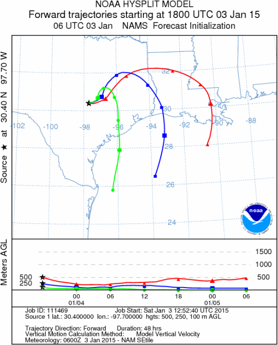
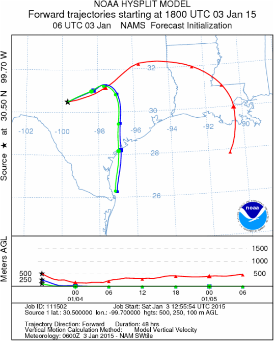
Trajectory weather: Air mass trajectories over Texas today will warm with westerly winds to begin the day. Temperatures will rise into the 50s over the Edwards Plateau with 60 degree temperatures expected in the edge communities and along the I-35 corridor. Winds will be light to moderate from the west moving anything that is entrained in the atmosphere towards east Texas. Overnight a northwesterly air flow takes over and winds begin to push southward towards the Gulf of Mexico. Cold temperatures in most areas will be in the 20s to mid-30s, and will result in the air being dense and very little lift as it moves. Sunday, the cold will linger with high temperatures in the 40s and just making the 50 degree mark in the southern edge communities. Winds will be from the north, moving anything entrained in the atmosphere towards the south. Winds will be moderate with gusty conditions from the Dallas/Fr. Worth metro region southwards along I-35 towards Austin. Overnight clear skies and cold conditions will bring temperatures back into the 20s. Over the plateaus light easterly breezes will occur whereas the edge communities will remain with a stronger southerly flow. The string of cold days and nights along with the precipitation should hinder pollination today as conditions warm into the 50s. The return to colder conditions tomorrow with most areas not getting into the 50 degree range should also hamper and significant release
OUTLOOK: ****** Low to Moderate Threat today and Low Threat Tomorrow *** poor conditions for pollen release today and tomorrow with the tree populations having been exposed to prolonged cold conditions. It usually takes a day or two for significant pollination to occur after such events. Today temperatures will get into the 50s and 60s so some pollen may be released but we do not expect large amounts. The air trajectories show that the air is dense and will stay close to the ground, thus also eliminating and pollen that is released. Tomorrow cold conditions will once again hinder the overall release although there may be areas where greater concentrations do occur. Environments (urban area) in which low temperatures are tempered will see higher levels of entrained pollen than natural settings.
Mountain Cedar location(s): Edwards Plateau, Texas.
Regional weather: Saturday, January 3 and Sunday January 4 – TX/OK: Across the region today conditions will be warming from the colder conditions over New Year’s day and yesterday. Today will be warmer across the region and then cool once again tomorrow. Mostly cloudy conditions and a chance of precipitation this morning will remain in the southern Oklahoma area. Oklahoma City will still have a 30% chance of snow or rain. To the south the day will begin with mostly to partly cloudy skies that will be clearing for sunny conditions most of the day. Temperatures will climb to the mid-50s across the Plateau. In the surrounding communities temperatures will get above the 60 degree mark. Winds will be from the west at light conditions but climb to moderate strengths is the afternoon. Tonight mostly clear to clear skies will prevail with low temperatures in the 20s across the Plateau and the mid-30s in the edge communities. In southern Oklahoma, partly cloudy skies will occur with low temperatures in the lower 20s. Across the region the westerly flow that occurred during the day will be replaced by a dominant northwesterly breeze at light conditions. Tomorrow sunny skies should prevail across the entire forecast area. However, moderate winds from the north will dominate and thus temperatures will struggle to get into the 40’s. Only in the southern edge areas of the Edwards Plateau are temperatures in the 50s expected. To the north winds will become moderate, with gusts of 30 miles per hour expected. Sunday night low temperatures take over once again with clear skies. Across the Plateau and in the edge communities low temperatures are expected to be in the 20s, and northern Texas into Oklahoma will see readings in the teens.
Trajectory weather: Air mass trajectories over Texas today will warm with westerly winds to begin the day. Temperatures will rise into the 50s over the Edwards Plateau with 60 degree temperatures expected in the edge communities and along the I-35 corridor. Winds will be light to moderate from the west moving anything that is entrained in the atmosphere towards east Texas. Overnight a northwesterly air flow takes over and winds begin to push southward towards the Gulf of Mexico. Cold temperatures in most areas will be in the 20s to mid-30s, and will result in the air being dense and very little lift as it moves. Sunday, the cold will linger with high temperatures in the 40s and just making the 50 degree mark in the southern edge communities. Winds will be from the north, moving anything entrained in the atmosphere towards the south. Winds will be moderate with gusty conditions from the Dallas/Fr. Worth metro region southwards along I-35 towards Austin. Overnight clear skies and cold conditions will bring temperatures back into the 20s. Over the plateaus light easterly breezes will occur whereas the edge communities will remain with a stronger southerly flow. The string of cold days and nights along with the precipitation should hinder pollination today as conditions warm into the 50s. The return to colder conditions tomorrow with most areas not getting into the 50 degree range should also hamper and significant release
OUTLOOK: ****** Low to Moderate Threat today and Low Threat Tomorrow *** poor conditions for pollen release today and tomorrow with the tree populations having been exposed to prolonged cold conditions. It usually takes a day or two for significant pollination to occur after such events. Today temperatures will get into the 50s and 60s so some pollen may be released but we do not expect large amounts. The air trajectories show that the air is dense and will stay close to the ground, thus also eliminating and pollen that is released. Tomorrow cold conditions will once again hinder the overall release although there may be areas where greater concentrations do occur. Environments (urban area) in which low temperatures are tempered will see higher levels of entrained pollen than natural settings.
Trajectory
Start (s) (shown by black stars on map):
Austin, TX
Austin, TX
Junction, TX
Sonora, TX

Matrix of sites across the Edwards Plateau (100 meters; 12:00 pm cst)
Prepared by: Estelle Levetin (Faculty of Biological Science, The University of Tulsa, 800 S. Tucker Dr., Tulsa, OK 74104) and Peter K Van de Water (Department of Earth and Environmental Science, California State University Fresno, 2576 East San Ramon Avenue, M/S ST24, Fresno CA 93740-8039). This forecast gives the anticipated future track of released Mountain Cedar pollen, weather conditions over the region and along the forecast pathway, and an estimated time of arrival for various metropolitan areas.Questions: Aerobiology Lab e-mail: [email protected]
Return to ForecastingHome Page
Return to ForecastingHome Page
