|
Metropolitan Area
Dallas Austin San Antonio |
Exposure Risk
Low High High |
Date Issued: 12 January, 2015
Mountain Cedar location(s): Edwards Plateau, Texas.
Regional weather: Monday, January 12 – TX/OK: Across the region today conditions will be warming with the warmest areas being in Texas and reaching the 50s to low 60s.. Skies across Texas will be mostly cloudy with a chance of fog this morning in the edge communities from San Antonio to Austin and further north. The Edwards Plateau will warm into the low 50s in its central portion whereas to the west temperatures will remain in the 40s. The Dallas/Ft Worth metro area as well as further north into southern Oklahoma will be in the mid- to low 40s. Across the region winds will be from the north at moderate to strong conditions. Air flow across Texas will be from the north bringing colder conditions back across the area. Winds will be strong, gusting to 25+ miles per hour in the edge communities. Tonight mostly cloudy conditions will remain with temperatures returning into the mid-to upper 30s in the edge communities and the low 30s across the Plateau. To the far west low temperatures will be in the upper 20s. Winds will continue from the north and northeast at moderate conditions. Winds will remain gusty up to 25 miles per hour. Tomorrow the influx of cold air will hold temperatures in the 40s across the Plateau and in the edge communities. To the north in Dallas/Ft. Worth, temperatures will remain in the upper 30s, as will the Arbuckle Mountains in southern Oklahoma. Winds will be light to moderate from the north to northeast. Tomorrow night temperatures will drop into the mid-to low 30s and a 20% chance of precipitation will occur over the southern half of the Edwards Plateau and in the surrounding edge communities as well. Winds will be very light from the northeast to east.
Trajectory weather: Air mass trajectories over Texas today and tomorrow will move from the north toward the south beginning today and tonight at moderate wind speeds then decrease tomorrow and tomorrow night. The air will warm today across Texas with the southernmost communities seeing their highs reaching toward the 60 degree mark. Most of the Plateau will be in the 50s with only the areas to the furthest west having readings that remain in the 40 degree range. To the north, the Dallas/Ft. Worth area will remain in the 40s today as will areas in southern Oklahoma. Tonight, 30s return to central Texas, cooling into the mid-twenties in southern Oklahoma. Winds will remain from the north and northeast at moderate conditions with the edge communities having gusty winds with speeds approaching 25 miles per hour. The colder conditions will linger tomorrow as temperatures in the 40s will be the maximum across the entire state and north into Oklahoma. Winds will be decreasing to moderate condition from the north and northeast. By tomorrow night similar temperatures will occur but there will be an influx of moisture with southern Oklahoma having a 30% chance of snow and the edge communities having a 20% chance of precipitation in some form. After today, weather returns back to cold conditions. Today will be the best day for pollen dispersal, entrainment and travel. The air will be cold but winds speeds will be moderate to high and thus we expect pollen in the atmosphere. In places, such as the surrounding edge communities, the threat will be severe. Other areas where the winds will be calmer the threat will be high. Tomorrow and tomorrow night conditions deteriorate again and thus we do not expect significant amounts of pollen to be released. However there may still be loose pollen that will become airborne.
OUTLOOK: *** High Threat today and Moderate Threat Tomorrow. The tree populations will warm today but tonight and tomorrow they will continue to be exposed to prolonged cold then once again wet conditions. Today conditions will be warming with most of the tree populations reaching into the 50s and low 60s. As the area warms we expect there to be significant release of pollen and accompanied by moderate winds that will gust to strong conditions will entrain pollen and move it downwind. The air, however will be dense and keep to the ground level thus much of the entrained pollen will be remove by impaction. Tonight, temperatures drop back into the 30’s and low 40s where they will stay tomorrow. Winds will remain from the north to northeast with highs in remaining in the 40s. Tomorrow night moisture moves back in with a chance of snow in north Texas and southern Oklahoma. There will also be a slight chance of rain in the surrounding communities tomorrow night. The potential for pollen being released, entrained in the atmosphere will be good today. We are expecting that southern areas may see significant concentrations locally within the areas where trees occur. The dense air and moderate wind speeds should keep an entrained pollen moving but at or near ground level. For these reasons we are expecting pockets of heavy concentration but restricted to local areas and not a significant downwind dispersal.
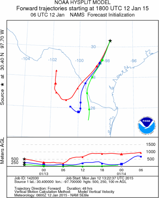
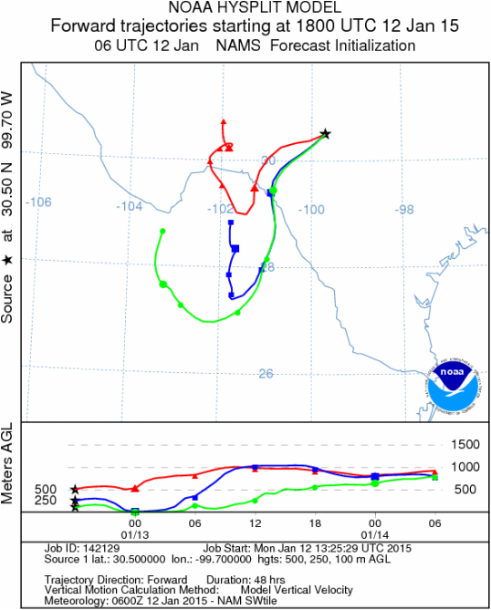
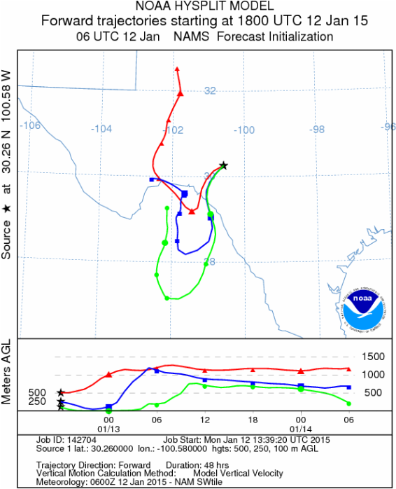
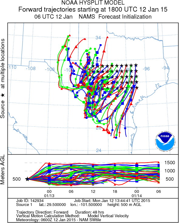
Trajectory Start (s) (shown by black stars on map):
Austin, TX
Junction, TX
Sonora, TX
Matrix of sites across the Edwards Plateau (100 meters; 12:00 pm cst)
Prepared by: Estelle Levetin (Faculty of Biological Science, The University of Tulsa, 800 S. Tucker Dr., Tulsa, OK 74104) and Peter K Van de Water (Department of Earth and Environmental Science, California State University Fresno, 2576 East San Ramon Avenue, M/S ST24, Fresno CA 93740-8039). This forecast gives the anticipated future track of released Mountain Cedar pollen, weather conditions over the region and along the forecast pathway, and an estimated time of arrival for various metropolitan areas.Questions: Aerobiology Lab e-mail: [email protected]
Return to ForecastingHome Page
Return to ForecastingHome Page
