|
Metropolitan Area
Dallas Austin San Antonio |
Exposure Risk
High Severe Severe |
Date Issued:
Mountain Cedar location(s): Edwards Plateau, Texas.
Regional weather: Monday, January 19 – TX/OK: Across the region today conditions will be remain warm with highs expected in the low 70 degree range in most areas. Northern Texas and southern Oklahoma will be in the mid to upper 60s. Skies will be sunny to mostly sunny and winds will be light from the southwest. In the southernmost areas of the Edwards Plateau winds will be more from the west. The clear skies will extend overnight into tomorrow. Tonight the lows will be in the upper 30s in the coldest areas across the Edwards Plateau and north of the Dallas/Ft. Worth metro area. In the surrounding communities lows will bottom out in the 40s. Tomorrow sunny to mostly sunny skies will remain, except to the north where partly cloudy conditions will build during the day and overnight. Over the Edwards Plateau high temperatures are expected to reach into the 70s once again. There will be slight cooling around the edge with southwestern areas reaching the mid to upper 60s and to the north in Dallas/Ft. Worth where highs will be in the mid 60’s cooling northward with central Oklahoma only in the mid-50s. Winds to the north will be turning coming from the north. Tomorrow night partly cloudy skies will continue to build southward. To the north lows will dip towards the freezing mark. Across the Edwards Plateau lows will be in the mid to upper 30s, and the surrounding areas will be in the mid- to upper 40s. Overall conditions will be good for pollen dissemination and dispersal.
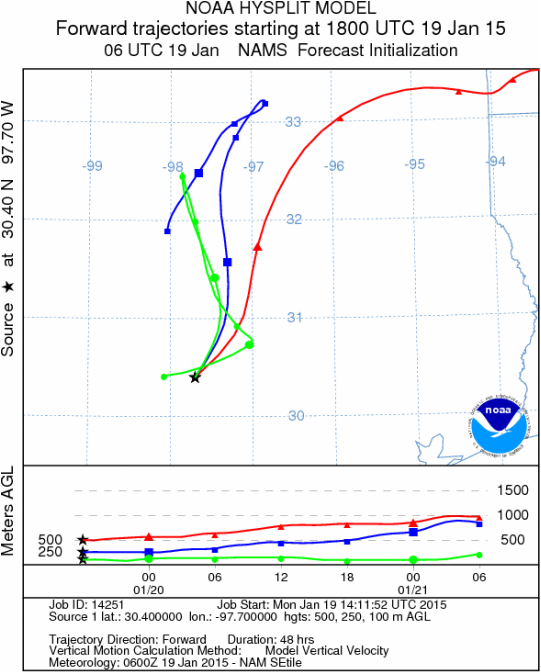
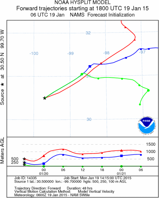
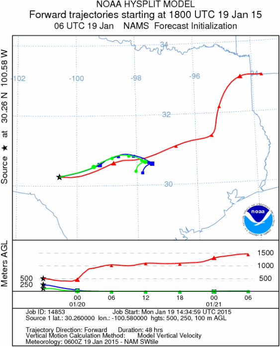
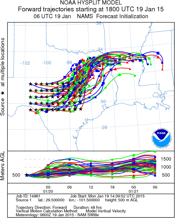
Trajectory weather: Air mass trajectories over Texas will move initially from the south and southwest towards the north and northeast on light wind conditions today and tonight. Tomorrow a more northerly wind will begin to push southward with slight cooling. As the change in air direction pushes southward gusty conditions will accompany the front. Therefore tomorrow gusts of moderate strength will occur in northern Texas. The change to winds coming from the north and northwest will also occur on the western side of the Edwards Plateau. Temperatures overall will remain mild to warm with high temperatures in the 60s and 70s. Across the region the air at the ground surface remain dense with little buoyancy over the forecast period. Above the surface, conditions will differ with stronger winds that will mix the atmosphere. The trajectories show the air moving from central Texas northeastward over northeastern Texas. The light winds will result in the overall flow being light and not moving significant distances.
OUTLOOK: ***Severe Threat today and Severe threat Tomorrow. Today conditions will be very good with high temperature in the 60 and 70 degree range with sunny skies. Tomorrow temperatures will cool slightly to the mid- and upper 60s remaining under sunny skies. Pollen release should be continuing, however winds will remain light and variable at low levels. The potential for pollen being released and entrained in the atmosphere will be good both days. However, once entrained the dense air at the ground may hamper long distance travel. Today the winds will move towards the north and northeast as most areas will see a southwest wind at light levels. Tomorrow, northerly winds will eventually take over and tomorrow night the overall flow will once again be from the north. The trajectories show little buoyancy and thus entrained pollen will be moving in the lower atmosphere where impaction is common and will have the greatest effect upon allergy sufferers.
Mountain Cedar location(s): Edwards Plateau, Texas.
Regional weather: Monday, January 19 – TX/OK: Across the region today conditions will be remain warm with highs expected in the low 70 degree range in most areas. Northern Texas and southern Oklahoma will be in the mid to upper 60s. Skies will be sunny to mostly sunny and winds will be light from the southwest. In the southernmost areas of the Edwards Plateau winds will be more from the west. The clear skies will extend overnight into tomorrow. Tonight the lows will be in the upper 30s in the coldest areas across the Edwards Plateau and north of the Dallas/Ft. Worth metro area. In the surrounding communities lows will bottom out in the 40s. Tomorrow sunny to mostly sunny skies will remain, except to the north where partly cloudy conditions will build during the day and overnight. Over the Edwards Plateau high temperatures are expected to reach into the 70s once again. There will be slight cooling around the edge with southwestern areas reaching the mid to upper 60s and to the north in Dallas/Ft. Worth where highs will be in the mid 60’s cooling northward with central Oklahoma only in the mid-50s. Winds to the north will be turning coming from the north. Tomorrow night partly cloudy skies will continue to build southward. To the north lows will dip towards the freezing mark. Across the Edwards Plateau lows will be in the mid to upper 30s, and the surrounding areas will be in the mid- to upper 40s. Overall conditions will be good for pollen dissemination and dispersal.
Trajectory weather: Air mass trajectories over Texas will move initially from the south and southwest towards the north and northeast on light wind conditions today and tonight. Tomorrow a more northerly wind will begin to push southward with slight cooling. As the change in air direction pushes southward gusty conditions will accompany the front. Therefore tomorrow gusts of moderate strength will occur in northern Texas. The change to winds coming from the north and northwest will also occur on the western side of the Edwards Plateau. Temperatures overall will remain mild to warm with high temperatures in the 60s and 70s. Across the region the air at the ground surface remain dense with little buoyancy over the forecast period. Above the surface, conditions will differ with stronger winds that will mix the atmosphere. The trajectories show the air moving from central Texas northeastward over northeastern Texas. The light winds will result in the overall flow being light and not moving significant distances.
OUTLOOK: ***Severe Threat today and Severe threat Tomorrow. Today conditions will be very good with high temperature in the 60 and 70 degree range with sunny skies. Tomorrow temperatures will cool slightly to the mid- and upper 60s remaining under sunny skies. Pollen release should be continuing, however winds will remain light and variable at low levels. The potential for pollen being released and entrained in the atmosphere will be good both days. However, once entrained the dense air at the ground may hamper long distance travel. Today the winds will move towards the north and northeast as most areas will see a southwest wind at light levels. Tomorrow, northerly winds will eventually take over and tomorrow night the overall flow will once again be from the north. The trajectories show little buoyancy and thus entrained pollen will be moving in the lower atmosphere where impaction is common and will have the greatest effect upon allergy sufferers.
Trajectory
Start (s) (shown by black stars on map):
Austin, TX
Austin, TX
Junction, TX
Sonora, TX
Matrix of sites across the Edwards Plateau (100 meters; 12:00 pm cst)
Prepared by: Estelle Levetin (Faculty of Biological Science, The University of Tulsa, 800 S. Tucker Dr., Tulsa, OK 74104) and Peter K Van de Water (Department of Earth and Environmental Science, California State University Fresno, 2576 East San Ramon Avenue, M/S ST24, Fresno CA 93740-8039). This forecast gives the anticipated future track of released Mountain Cedar pollen, weather conditions over the region and along the forecast pathway, and an estimated time of arrival for various metropolitan areas.Questions: Aerobiology Lab e-mail: [email protected]
Return to ForecastingHome Page
Return to ForecastingHome Page
