|
Metropolitan Area
Dallas Austin San Antonio |
Exposure Risk
Low Low Low |
Date Issued: 22 January, 2015
Mountain Cedar location(s): Thursday, January 22 – TX/OK: Edwards Plateau, Texas. Across the region today conditions will be rainy with the possibility of rain throughout the forecast period. Skies this morning will be mostly cloudy with the Edwards Plateau and surrounding communities continuing to have significant rainfall. Overnight into this morning many areas have received more than an inch of precipitation. Today, temperatures will be mostly in the 40s with only the southern edge communities making it into the low 50 degree range. The cloudy conditions and lower temperatures will extend northward into southern and central Oklahoma where early precipitation may fall with mixed snow showers. Winds today and tonight will be from the northeast at moderate to strong conditions, ten to twenty miles per hour. Tonight there will remain a significant chance of rain across the Edwards Plateau. Temperatures on the Plateau are expected to be in the low 30s with a chance of rain or snow mixed. Tomorrow the moisture will continue but begin to taper off as the system moves towards the east. Skies will begin to clear to the north in southern Oklahoma with temperatures rebounding into the high 40 degree range. Across Texas a chance of rain will continue with the greatest probability being in the central Plateau between Junction and Fredericksburg. High temperatures will only be in the 40s across the region with the warmest locations just crossing the 50 degree mark in the edge communities along the eastern plateau. Winds will continue from the north and northwest at moderate levels. Tomorrow night clear to mostly clear skies will occur with temperatures dropping into the 30s across the eastern Plateau and its surrounding communities along the I-35 corridor. On the Plateau and to the west temperatures will be in the upper 20’s. Winds will become light from the northwest
Trajectory weather: Air mass trajectories over Texas will be dominated by the system moving through the region. Rain is expected today across the areas with central Texas northward towards the Dallas/Ft. Worth metro region forecast for the greatest amounts. Temperatures today will generally be in the 40s with only the southern edge communities reaching the 50 degree mark. Tonight temperatures will drop into the 30s with showers and a chance in some areas of the moisture falling as snow or snow/rain mix. Tomorrow, winds will continue at moderate levels but come more from the north to northwest. The chance of precipitation will remain across the Plateau and into the edge communities. Temperatures will remain in the 40s across almost all of the area, the southernmost communities will have conditions just reach 50 degrees. Considering current rainfall combined with the significant chance of rainfall continuing across the region over the forecast period it is expected that most pollen will be removed from the atmosphere, and that little pollen will be released. Conditions will be wet over the forecast period, and the amount of pollen should be relatively low. The rain event itself should last through tomorrow with conditions beginning to change tomorrow night. It will be Friday night into Saturday before skies will begin to clear and the threat of pollen returns.
OUTLOOK: *** Low Threat today and Low threat Tomorrow. Today conditions will continue to be poor for pollen dispersal, entrainment and travel with rainfall across the region. High temperatures will remain in the 40s across the region as moisture continues to move across the Edwards Plateau. Winds at the surface will be from the northeast at moderate to strong conditions. Gusts of ~30 mile per hour are expected in the Dallas/Ft. Worth region. Tonight the chance of precipitation will continue but begin to diminish. The chance of rain, however will linger over the plateau for tomorrow and tomorrow night. Temperatures will be in the 40s in most areas. The southwestern Plateau will dip into the upper 30s as will northernmost Texas and the Oklahoma border region. Conditions area poor for pollen release today through tomorrow night. Looking towards the weekend, however, conditions will improve and pollen cones are expected to open bringing concentrations back into the atmosphere over Texas.
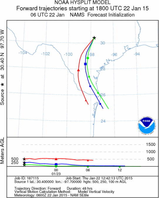
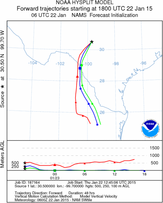
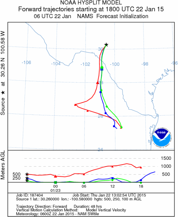
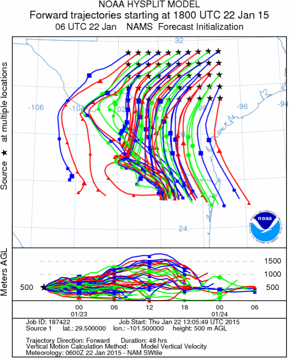
Trajectory
Start (s) (shown by black stars on map):
Austin, TX
Austin, TX
Junction, TX
Sonora, TX
Matrix of sites across the Edwards Plateau (100 meters; 12:00 pm cst)
Prepared by: Estelle Levetin (Faculty of Biological Science, The University of Tulsa, 800 S. Tucker Dr., Tulsa, OK 74104) and Peter K Van de Water (Department of Earth and Environmental Science, California State University Fresno, 2576 East San Ramon Avenue, M/S ST24, Fresno CA 93740-8039). This forecast gives the anticipated future track of released Mountain Cedar pollen, weather conditions over the region and along the forecast pathway, and an estimated time of arrival for various metropolitan areas.Questions: Aerobiology Lab e-mail: [email protected]
Return to ForecastingHome Page
Return to ForecastingHome Page
