|
Metropolitan Area
Dallas Austin San Antonio |
Exposure Risk
Low Moderate Moderate |
Date Issued: 23 January, 2015
Mountain Cedar location(s): Edwards Plateau, Texas.
Regional weather: Friday, January 23 – TX/OK: Across the region today conditions will be rainy with the showers ending this morning to early afternoon. The Edwards Plateau will have a 30% chance of precipitation. This morning some of the moisture may have fallen as snow, but little of it was expected to stick on the ground. The edge communities will have a 50% chance of rain today and even as far north as the Dallas/Ft. Worth area a 20% chance of precipitation will exist. Temperatures this afternoon will begin the warming process, but with the last couple of days of rain most areas will only get into the upper 40s. The edge communities will just make it to the 50s. Winds will be from the northwest at moderate to strong conditions. The San Antonio area may have gusts upwards of 25 miles per hour. Into the afternoon skies will begin to clear and clear skies are expected overnight. Temperatures tonight will be in the 20s across the Edwards Plateau and in the mid to lower 30s in the surrounding communities and northward along the I-35 corridor. Southern Oklahoma will drop to 30 overnight. Tomorrow the Plateau will retain partly cloudy skies whereas the rest of the region should begin the day with clear conditions. Temperatures tomorrow will rebound back into the mid- to upper 50s over the Plateau and north towards southern Oklahoma. The surrounding communities will have a chance of getting into the low 60s. Winds will continue from the northwest at light to moderate conditions. Tomorrow night clouds will build in over the Edwards Plateau and mostly clear skies will occur in Dallas/Ft. Worth area and to the north. Low temperatures will be in the 30s across Texas and southern Oklahoma.
Trajectory weather: Air mass trajectories over Texas will be dominated by the back side of the system moving through the region. Rain is expected this morning from the Dallas/Ft. Worth area southward across the area. The greatest chance of showers will be along the I-35 corridor on the eastern side of the Edwards Plateau. Temperatures today will generally be in the mid- to upper 40s with only the edge communities reaching the 50 degree mark. Tonight temperatures will drop into the upper twenties to the west and mid to lower 30s elsewhere. Winds will be from the west. Tomorrow the warming continues with temperatures about 10 degrees warmer. Whereas today the Plateau will be in the 40s getting close to 50 degrees, tomorrow the area will be in the 50s pushing 60. Winds will be light from the northwest. Overnight the area will drop into the low 30s under partly cloudy skies and light winds. The air over Texas for the forecast period will continue to be dense and thus moving along the ground surface. Cold temperatures overnight and today should retard pollen dispersal and travel, but conditions will improve for tomorrow. There may be some trees that can shed pollen today, but usually it takes a day after significant rainfall for levels to build back up. Today we expect minor amounts of pollen to be in the atmosphere but the amount will definitely climb tomorrow with sunny conditions and warmer winds.
OUTLOOK: *** Low to moderate Threat today and moderate to high threat Tomorrow. Today conditions will be poor for pollen dispersal, entrainment and travel with rainfall across the region overnight and into this morning. High temperatures will remain in the 40s across the region as moisture continues to move across the Edwards Plateau this morning, and any break will begin after noon. Winds at the surface will be from the north and northwest at moderate to strong gusty conditions. This afternoon the chance of precipitation will diminish. Temperatures will be in the 40s in most areas today then rise into the 50s tomorrow. The atmosphere is heavy and thus the trajectories will travel at ground surface where anything entrained within the atmosphere will be open for impaction on surfaces and removal from the air stream. Conditions are poor for pollen release today, but becoming better by tomorrow. Looking towards the weekend, however, conditions will improve and pollen cones are expected to open bringing concentrations back into the atmosphere over Texas.
Trajectory
Start (s) (shown by black stars on map):
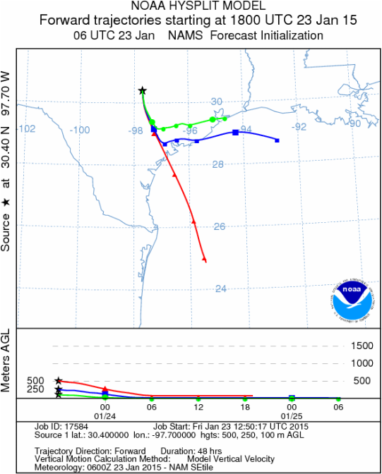
Austin, TX
Austin, TX
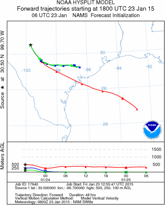
Junction, TX
Sonora, TX
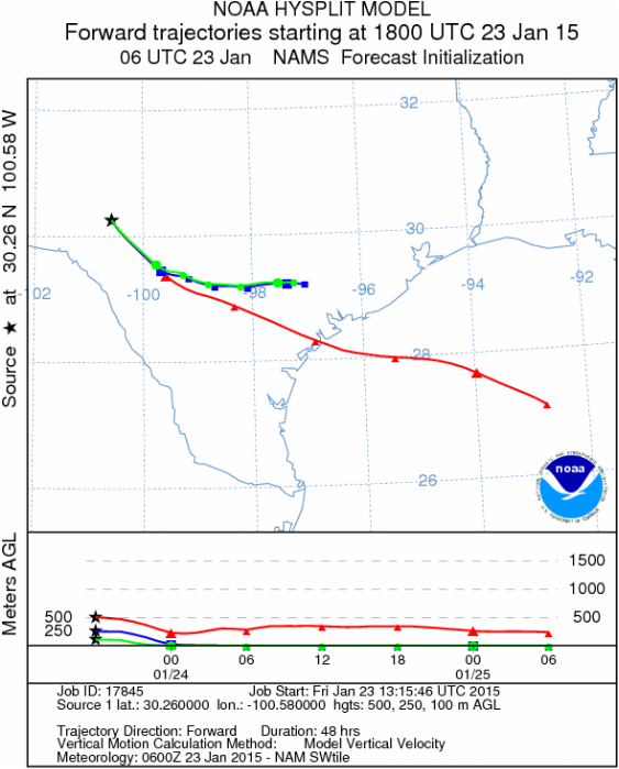
Matrix of sites across the Edwards Plateau (100 meters; 12:00 pm cst)
Prepared by: Estelle Levetin (Faculty of Biological Science, The University of Tulsa, 800 S. Tucker Dr., Tulsa, OK 74104) and Peter K Van de Water (Department of Earth and Environmental Science, California State University Fresno, 2576 East San Ramon Avenue, M/S ST24, Fresno CA 93740-8039). This forecast gives the anticipated future track of released Mountain Cedar pollen, weather conditions over the region and along the forecast pathway, and an estimated time of arrival for various metropolitan areas.Questions: Aerobiology Lab e-mail: [email protected]
Return to ForecastingHome Page
Return to ForecastingHome Page
