|
Metropolitan Area
Oklahoma City Tulsa St. Louis |
Exposure Risk
Low Low Low |
Date Issued: 24 January, 2015
Mountain Cedar location(s): Arbuckle Mountains, OK
Regional weather: Saturday, January 24 and Sunday, January 25 – TX/OK: Across the region today conditions will be clearing from the rain storm this week. Overall the region will be sunny with warming conditions. Across the western Edwards Plateau skies will be mostly sunny with a few clouds building towards the evening. Temperatures will climb to the upper 50s and winds will be light from the west. In the edge communities north to the Dallas/Ft. Worth metro region skies will be sunny and temperatures will reach for the low 60 degree mark. The overall westerly to northwesterly flow will extend into Oklahoma with high temperatures in the upper 50s. Overnight the north will remain clear and temperatures will drop to the mid- to upper 30s. To the south across Texas, partly cloudy skies will occur with temperatures in the mid- to low 30s. Winds will be very light primarily from the west to northwest. Sunday will continue the mild conditions with mostly sunny skies across the region. Temperatures will build into the mid- to upper 60s with the southernmost edge communities approaching the 70 degree mark. Winds will remain from the northwest at light conditions. Tomorrow night, mostly clear skies will occur with temperatures in the upper 30s to the north and across the western Edwards Plateau. The edge communities from San Antonio to Austin and north towards Dallas will only drop into the 40 degree range. Winds will be light, once again, from the northwest.
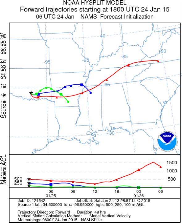
Trajectory weather: Air mass trajectories over southern Oklahoma will be dominated by a west to northwesterly flow across the region. Winds will be light from 5 to 10 miles per hour and the trajectories move towards the east. Weather conditions today will be nice with sunny skies and temperatures in the 50s today climbing into the 60s tomorrow. Tonight temperatures will drop into the thirties but will not flirt with the freezing mark. Tomorrow the area will be partly sunny and the region will mimic today’s conditions. Tomorrow conditions will see sunny to mostly sunny skies with temperatures in the 60s. Winds will remain, coming from the west at light levels. Tomorrow night mostly clear skies will extend across the area with lows in the upper 30s. Winds will remain from the northwest at light levels.
OUTLOOK: *** High Threat today and Severe threat Tomorrow. Today conditions will be very good for pollen dispersal. Entrainment and downwind travel will occur but the winds will be light and the air remains dense so it will be moving near the ground surface. High temperatures will climb in to the 50s today and then the 60s tomorrow. Winds at the surface will be from the north, northwest at light levels. The atmosphere is heavy and thus the trajectories will travel at ground surface where anything entrained within the atmosphere will be open for impaction on surfaces and removal from the air stream. Tomorrow the warming will continue and thus the atmosphere should be getting mor buoyant. As conditions improve pollen cones are expected to open bringing higher and eventually significant concentrations back into the atmosphere over the region.
Trajectory Start (s) (shown by black star on map): Davis, OK.
Mountain Cedar location(s): Arbuckle Mountains, OK
Regional weather: Saturday, January 24 and Sunday, January 25 – TX/OK: Across the region today conditions will be clearing from the rain storm this week. Overall the region will be sunny with warming conditions. Across the western Edwards Plateau skies will be mostly sunny with a few clouds building towards the evening. Temperatures will climb to the upper 50s and winds will be light from the west. In the edge communities north to the Dallas/Ft. Worth metro region skies will be sunny and temperatures will reach for the low 60 degree mark. The overall westerly to northwesterly flow will extend into Oklahoma with high temperatures in the upper 50s. Overnight the north will remain clear and temperatures will drop to the mid- to upper 30s. To the south across Texas, partly cloudy skies will occur with temperatures in the mid- to low 30s. Winds will be very light primarily from the west to northwest. Sunday will continue the mild conditions with mostly sunny skies across the region. Temperatures will build into the mid- to upper 60s with the southernmost edge communities approaching the 70 degree mark. Winds will remain from the northwest at light conditions. Tomorrow night, mostly clear skies will occur with temperatures in the upper 30s to the north and across the western Edwards Plateau. The edge communities from San Antonio to Austin and north towards Dallas will only drop into the 40 degree range. Winds will be light, once again, from the northwest.
Trajectory weather: Air mass trajectories over southern Oklahoma will be dominated by a west to northwesterly flow across the region. Winds will be light from 5 to 10 miles per hour and the trajectories move towards the east. Weather conditions today will be nice with sunny skies and temperatures in the 50s today climbing into the 60s tomorrow. Tonight temperatures will drop into the thirties but will not flirt with the freezing mark. Tomorrow the area will be partly sunny and the region will mimic today’s conditions. Tomorrow conditions will see sunny to mostly sunny skies with temperatures in the 60s. Winds will remain, coming from the west at light levels. Tomorrow night mostly clear skies will extend across the area with lows in the upper 30s. Winds will remain from the northwest at light levels.
OUTLOOK: *** High Threat today and Severe threat Tomorrow. Today conditions will be very good for pollen dispersal. Entrainment and downwind travel will occur but the winds will be light and the air remains dense so it will be moving near the ground surface. High temperatures will climb in to the 50s today and then the 60s tomorrow. Winds at the surface will be from the north, northwest at light levels. The atmosphere is heavy and thus the trajectories will travel at ground surface where anything entrained within the atmosphere will be open for impaction on surfaces and removal from the air stream. Tomorrow the warming will continue and thus the atmosphere should be getting mor buoyant. As conditions improve pollen cones are expected to open bringing higher and eventually significant concentrations back into the atmosphere over the region.
Trajectory Start (s) (shown by black star on map): Davis, OK.
Prepared by: Estelle Levetin (Faculty of Biological Science, The University of Tulsa, 800 S. Tucker Dr., Tulsa, OK 74104) and Peter K Van de Water (Department of Earth and Environmental Science, California State University Fresno, 2576 East San Ramon Avenue, M/S ST24, Fresno CA 93740-8039). This forecast gives the anticipated future track of released Mountain Cedar pollen, weather conditions over the region and along the forecast pathway, and an estimated time of arrival for various metropolitan areas.
Questions: Aerobiology Lab e-mail: [email protected]
Return to ForecastingHome Page
Questions: Aerobiology Lab e-mail: [email protected]
Return to ForecastingHome Page
