|
Metropolitan Area
Dallas Austin San Antonio |
Exposure Risk
High Severe Severe |
Date Issued: 26 January, 2015
Mountain Cedar location(s): Edwards Plateau, Texas.
Regional weather: Monday, January 26 – TX/OK: Across the region today conditions will be sunny with a warming atmosphere. The region will be under clear skies and sunny conditions this morning. However, in the far southwestern area of the Edwards Plateau partly cloudy conditions will build-in this afternoon. Temperatures will be warm today with the central portion of the forecast areas in the low 70s. To the north in southern Oklahoma and to the southwest over the Edwards Plateau temperatures will be in the 60s. Winds will be light over the region and from the west. Overnight conditions will cool into the mid to lower 40s. The western side of the Edwards Plateau and north along the border area in southern Oklahoma lows will fall to the mid- 30s. Winds will once again be from the west at light conditions. Tomorrow will mostly be a repeat of today with regional temperatures getting into the low 70s. Winds will begin to turn with the southwestern Plateau having winds from the southwest and the other regions with wind from the west to northwest. Winds will remain light. Overnight partly cloudy skies will build in over Texas and evening temperatures will be mild with most areas in the low to mid 40’s Winds will mostly be from the west at light levels.
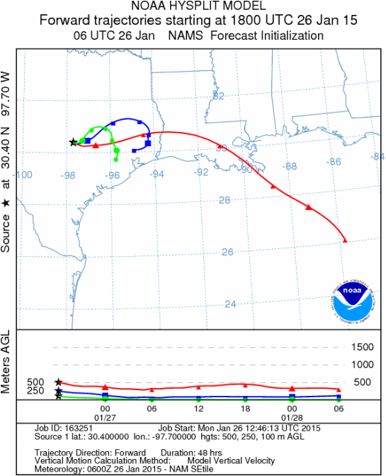
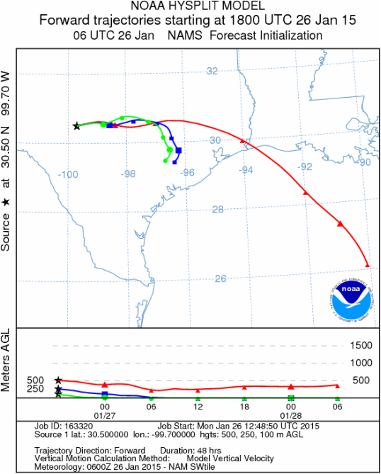
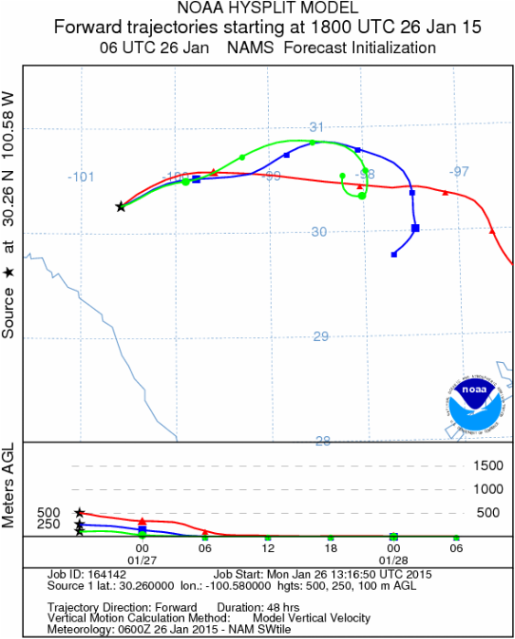
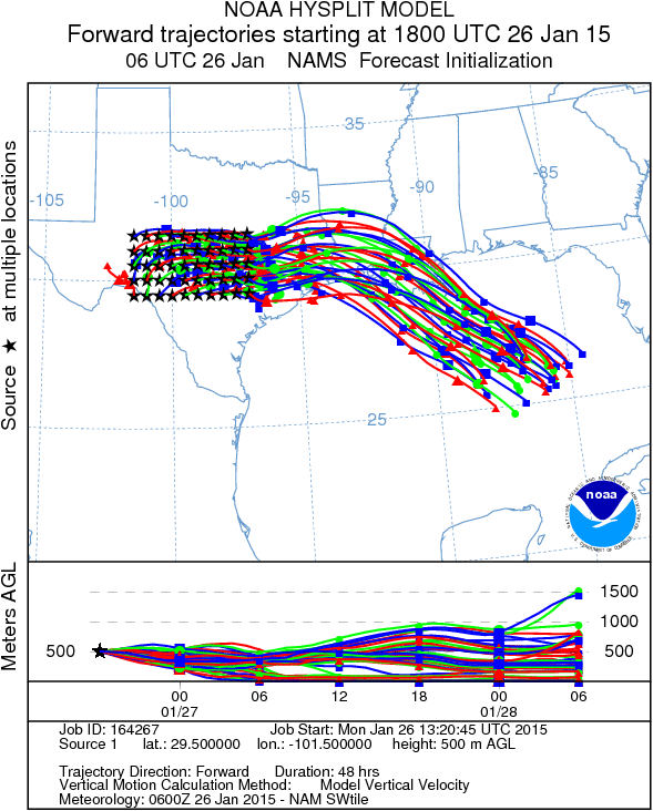
Trajectory weather: Air mass trajectories over Texas will be dominated by a west to northwesterly flow across the region. Winds will be light from 5 to 10 miles per hour and the trajectories move towards the east. Weather conditions today will be nice with sunny skies and temperatures in the 70s today and tomorrow. Tonight temperatures will drop into the upper mid- to low 40s. Tomorrow the area will be sunny again and the region will mimic today’s conditions but slightly warmer. Tomorrow conditions will again be sunny to mostly with temperatures in the 70s. Winds will continue from the west at light levels. The air will remain dense and the trajectories show movement along the ground. Impaction of pollen and removal from the air stream will be the primary effect downstream. Tomorrow night mostly clear skies will extend across the area with lows in the 40s. Winds will remain with a generally westerly flow.
OUTLOOK: ***Severe Threat today and Severe threat Tomorrow. Today conditions will be very good for pollen dispersal. Entrainment and downwind travel will occur but the winds will be light and the air remains dense so it will be moving near the ground surface. High temperatures will climb in to the 70s today and tomorrow. Winds at the surface will be from the north, northwest at light levels. The trajectories move mostly to the east. The atmosphere is heavy and thus the trajectories will travel at ground surface where anything entrained within the atmosphere will be open for impaction on surfaces and removal from the air stream. As conditions improve pollen cones are expected to open bringing higher and eventually significant concentrations back into the atmosphere over the region. However, with the light winds the greatest pollen levels will occur close to where there are trees.
Mountain Cedar location(s): Edwards Plateau, Texas.
Regional weather: Monday, January 26 – TX/OK: Across the region today conditions will be sunny with a warming atmosphere. The region will be under clear skies and sunny conditions this morning. However, in the far southwestern area of the Edwards Plateau partly cloudy conditions will build-in this afternoon. Temperatures will be warm today with the central portion of the forecast areas in the low 70s. To the north in southern Oklahoma and to the southwest over the Edwards Plateau temperatures will be in the 60s. Winds will be light over the region and from the west. Overnight conditions will cool into the mid to lower 40s. The western side of the Edwards Plateau and north along the border area in southern Oklahoma lows will fall to the mid- 30s. Winds will once again be from the west at light conditions. Tomorrow will mostly be a repeat of today with regional temperatures getting into the low 70s. Winds will begin to turn with the southwestern Plateau having winds from the southwest and the other regions with wind from the west to northwest. Winds will remain light. Overnight partly cloudy skies will build in over Texas and evening temperatures will be mild with most areas in the low to mid 40’s Winds will mostly be from the west at light levels.
Trajectory weather: Air mass trajectories over Texas will be dominated by a west to northwesterly flow across the region. Winds will be light from 5 to 10 miles per hour and the trajectories move towards the east. Weather conditions today will be nice with sunny skies and temperatures in the 70s today and tomorrow. Tonight temperatures will drop into the upper mid- to low 40s. Tomorrow the area will be sunny again and the region will mimic today’s conditions but slightly warmer. Tomorrow conditions will again be sunny to mostly with temperatures in the 70s. Winds will continue from the west at light levels. The air will remain dense and the trajectories show movement along the ground. Impaction of pollen and removal from the air stream will be the primary effect downstream. Tomorrow night mostly clear skies will extend across the area with lows in the 40s. Winds will remain with a generally westerly flow.
OUTLOOK: ***Severe Threat today and Severe threat Tomorrow. Today conditions will be very good for pollen dispersal. Entrainment and downwind travel will occur but the winds will be light and the air remains dense so it will be moving near the ground surface. High temperatures will climb in to the 70s today and tomorrow. Winds at the surface will be from the north, northwest at light levels. The trajectories move mostly to the east. The atmosphere is heavy and thus the trajectories will travel at ground surface where anything entrained within the atmosphere will be open for impaction on surfaces and removal from the air stream. As conditions improve pollen cones are expected to open bringing higher and eventually significant concentrations back into the atmosphere over the region. However, with the light winds the greatest pollen levels will occur close to where there are trees.
Trajectory Start (s) (shown by black stars on map):
Austin, TX
Junction, TX
Sonora, TX
Matrix of sites across the Edwards Plateau (100 meters; 12:00 pm cst)
Prepared by: Estelle Levetin (Faculty of Biological Science, The University of Tulsa, 800 S. Tucker Dr., Tulsa, OK 74104) and Peter K Van de Water (Department of Earth and Environmental Science, California State University Fresno, 2576 East San Ramon Avenue, M/S ST24, Fresno CA 93740-8039). This forecast gives the anticipated future track of released Mountain Cedar pollen, weather conditions over the region and along the forecast pathway, and an estimated time of arrival for various metropolitan areas.Questions: Aerobiology Lab e-mail: [email protected]
Return to ForecastingHome Page
Return to ForecastingHome Page
