|
Metropolitan Area
Dallas Austin San Antonio |
Exposure Risk
Severe Severe Severe |
Date Issued: 27 January, 2015
Mountain Cedar location(s): Edwards Plateau, Texas.
Regional weather: Tuesday, January 27 – TX/OK: Across the region today conditions will be sunny and warm. The region will be under clear skies and sunny conditions this morning. However, in the far southwestern area of the Edwards Plateau partly cloudy conditions will begin the day but will soon clear. Temperatures will be warm today with the central portion of the forecast areas in the mid- to upper 70s. To the north in southern Oklahoma temperatures will be in the mid- to lower 70s as well. Winds will be light over the region to begin with and a mixed pattern that will shift tonight to a dominantly south to southwesterly source. Overnight conditions will only cool into the mid to upper 40s. Winds from the south will be building overnight. Tomorrow skies will be mostly sunny to sunny. Temperatures will build once again into the 70s with a near repeat of today. Winds will continue to strengthen coming from the south at moderate conditions. Tonight temperatures will remain mild with lows mostly in the upper 40s across the Edwards Plateau and the border region from Dallas into southern Oklahoma. The edge communities surrounding the Edwards Plateau will be mild with low temperatures staying in the mid- to lower 50s.
Trajectory weather: : Air mass trajectories over Texas will be light and somewhat mixed this morning, with light and variable conditions to the north, northerly breezes in the edge communities and a building flow from the southwest across the Edwards Plateau. Tonight the southern breeze will begin to dominate the region and will build into moderate conditions tomorrow. Winds will move entrained material towards the north beginning tonight on increasing southwesterly winds. Temperatures will be warm both today and tomorrow with highs expected in the 70’s. Conditions are very good for pollen release across the region today and tomorrow. In additions the air is becoming more buoyant over the forecast period. Long distance travel and dispersal at some distance is expected today and tomorrow. With the southerly winds the most affected areas will be north of the pollinating trees.
OUTLOOK: ***Severe Threat today and Severe threat Tomorrow. Today and tomorrow conditions will be very good for pollen dispersal. Entrainment and downwind travel will occur, with the winds light to begin with but building over the forecast period. High temperatures will climb in to the 70s today and tomorrow. Winds at the surface will be start somewhat mixed at light levels, but will build from the southwest this afternoon, tonight and tomorrow. The trajectories move to the north and the atmosphere is becoming lighter and more buoyant and thus the trajectories will have significant pollen entrained within the atmosphere. These conditions will bring significant concentrations into the atmosphere over the region. The communities of central to north Texas, as well as Oklahoma will see some of their highest pollen levels this season.
Trajectory
Start (s) (shown by black stars on map):
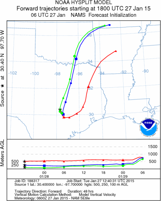
Austin, TX
Austin, TX
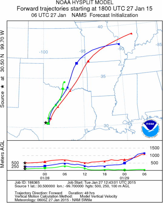
Junction, TX
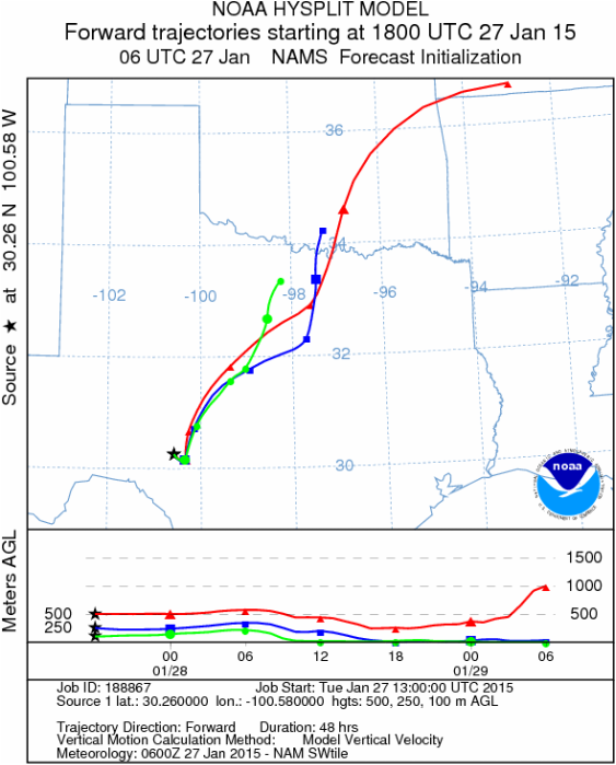
Sonora, TX
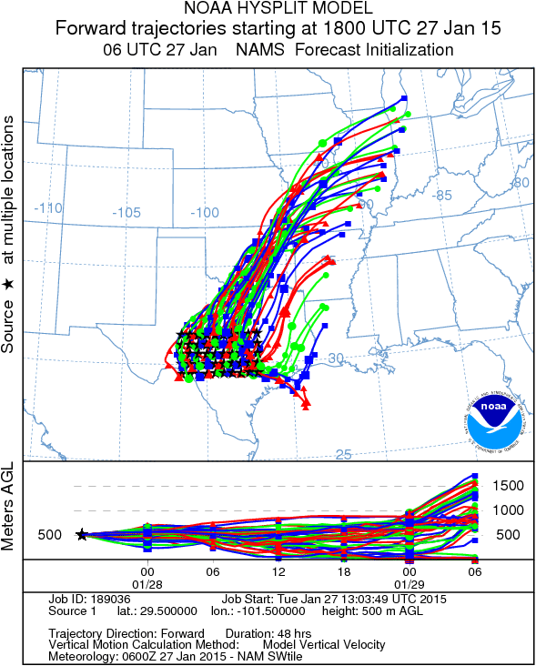
Matrix of sites across the Edwards Plateau (100 meters; 12:00 pm cst)
Prepared by: Estelle Levetin (Faculty of Biological Science, The University of Tulsa, 800 S. Tucker Dr., Tulsa, OK 74104) and Peter K Van de Water (Department of Earth and Environmental Science, California State University Fresno, 2576 East San Ramon Avenue, M/S ST24, Fresno CA 93740-8039). This forecast gives the anticipated future track of released Mountain Cedar pollen, weather conditions over the region and along the forecast pathway, and an estimated time of arrival for various metropolitan areas.Questions: Aerobiology Lab e-mail: [email protected]
Return to ForecastingHome Page
Return to ForecastingHome Page
