|
Metropolitan Area
Oklahoma City Tulsa St. Louis |
Exposure Risk
Low Low Low |
Date Issued: 29 January 2015
Mountain Cedar location(s): Arbuckle Mountains, OK
Regional weather: Monday: Thursday, January 29 – TX/OK: Across the region today conditions will be mostly sunny to the north and partly cloudy building to mostly cloudy to the south. Temperatures will remain warm with the Edwards Plateau region in the upper 60s and low 70s. To the north, the Dallas/Ft. Worth metro region will top out in the low 60s and the border region will stay in the upper 50s. Winds will start from the north and northeast across the Edwards Plateau northward. To the north winds will be moderate to strong to begin the day. Those conditions will move southward and then start to rotate coming more from the northeast this afternoon. Tonight partly cloudy skies will occur to the north and across and around the edge of the Edwards Plateau mostly cloudy conditions will build. Low temperatures will be in the 40s to the east and 30s toward the western side of the Plateau. In southern Oklahoma lows will drop into the mid-30s. Winds will be from the northeast at moderate levels (10 to 15 miles per hour). Tomorrow, northern areas will begin the day partly cloudy with high temperatures in the lower 50s. Winds will be light from the east. To the south across Texas, mostly cloudy conditions will build in areas surrounding the Edwards Plateau from the Dallas/Ft. Worth metro area to San Antonio. On the Plateau cloudy conditions will prevail. There will be a 20% to 30% chance of rain to the east and a 60% to 70% chance of rain on the western side of the Edwards Plateau. Lows will remain in the 40s and winds will be light to moderate from the east.
Trajectory weather: Air mass trajectories over southern Oklahoma will be mixed today with conditions to the north getting into the 50s under a moderate wind from the north. Skies will be mostly sunny. Tonight partly cloudy skies will signal a change with the chance of precipitation moving into the region tomorrow into the weekend. Low temperatures will be in the mid-30s tonight and the winds will be from the northeast at about 10 miles per hour. Tomorrow will dawn with partly cloudy conditions and colder air. The high temperature tomorrow will be in the low 50s with an east wind of about 10 miles per hour. During the afternoon the partly cloudy skies will build in to mostly cloudy conditions. There will be a 40% chance of showers with the low temperatures in the upper 30s tomorrow night. The rain will be building in from the southwest where the Plateau will see a 70% chance of showers overnight. Conditions will be declining for pollen release today with temperatures in the upper 50s and then in the low 50s tomorrow. However, only with rain will the atmosphere be washed and concentration drop to very low levels. With that being said, across the region today conditions should improve. The air is relatively stable but we expect dispersal today and tomorrow to a lesser degree.
OUTLOOK: *** High Threat Today and High Threat Tomorrow*** Today and tomorrow conditions will continue to be good for pollen dispersal, although conditions will be deteriorating towards the weekend. Entrainment and downwind travel will occur, with the winds building and changing direction over the forecast period. High temperatures will climb in to the upper 50s today and the low 50s tomorrow. Winds at the surface will moderate to strong from the north today, declining tonight. Tomorrow winds will be from the east at 10 miles per hour.
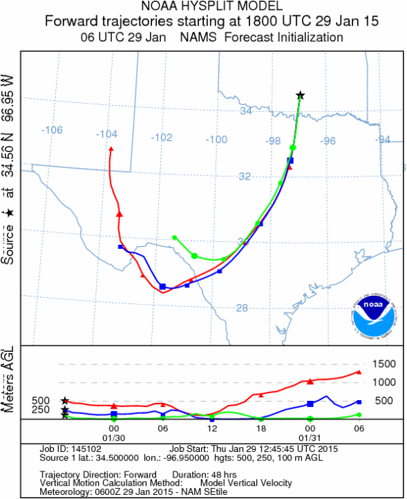
Trajectory Start (s) (shown by black star on map): Davis, OK.
Mountain Cedar location(s): Arbuckle Mountains, OK
Regional weather: Monday: Thursday, January 29 – TX/OK: Across the region today conditions will be mostly sunny to the north and partly cloudy building to mostly cloudy to the south. Temperatures will remain warm with the Edwards Plateau region in the upper 60s and low 70s. To the north, the Dallas/Ft. Worth metro region will top out in the low 60s and the border region will stay in the upper 50s. Winds will start from the north and northeast across the Edwards Plateau northward. To the north winds will be moderate to strong to begin the day. Those conditions will move southward and then start to rotate coming more from the northeast this afternoon. Tonight partly cloudy skies will occur to the north and across and around the edge of the Edwards Plateau mostly cloudy conditions will build. Low temperatures will be in the 40s to the east and 30s toward the western side of the Plateau. In southern Oklahoma lows will drop into the mid-30s. Winds will be from the northeast at moderate levels (10 to 15 miles per hour). Tomorrow, northern areas will begin the day partly cloudy with high temperatures in the lower 50s. Winds will be light from the east. To the south across Texas, mostly cloudy conditions will build in areas surrounding the Edwards Plateau from the Dallas/Ft. Worth metro area to San Antonio. On the Plateau cloudy conditions will prevail. There will be a 20% to 30% chance of rain to the east and a 60% to 70% chance of rain on the western side of the Edwards Plateau. Lows will remain in the 40s and winds will be light to moderate from the east.
Trajectory weather: Air mass trajectories over southern Oklahoma will be mixed today with conditions to the north getting into the 50s under a moderate wind from the north. Skies will be mostly sunny. Tonight partly cloudy skies will signal a change with the chance of precipitation moving into the region tomorrow into the weekend. Low temperatures will be in the mid-30s tonight and the winds will be from the northeast at about 10 miles per hour. Tomorrow will dawn with partly cloudy conditions and colder air. The high temperature tomorrow will be in the low 50s with an east wind of about 10 miles per hour. During the afternoon the partly cloudy skies will build in to mostly cloudy conditions. There will be a 40% chance of showers with the low temperatures in the upper 30s tomorrow night. The rain will be building in from the southwest where the Plateau will see a 70% chance of showers overnight. Conditions will be declining for pollen release today with temperatures in the upper 50s and then in the low 50s tomorrow. However, only with rain will the atmosphere be washed and concentration drop to very low levels. With that being said, across the region today conditions should improve. The air is relatively stable but we expect dispersal today and tomorrow to a lesser degree.
OUTLOOK: *** High Threat Today and High Threat Tomorrow*** Today and tomorrow conditions will continue to be good for pollen dispersal, although conditions will be deteriorating towards the weekend. Entrainment and downwind travel will occur, with the winds building and changing direction over the forecast period. High temperatures will climb in to the upper 50s today and the low 50s tomorrow. Winds at the surface will moderate to strong from the north today, declining tonight. Tomorrow winds will be from the east at 10 miles per hour.
Trajectory Start (s) (shown by black star on map): Davis, OK.
Prepared by: Estelle Levetin (Faculty of Biological Science, The University of Tulsa, 800 S. Tucker Dr., Tulsa, OK 74104) and Peter K Van de Water (Department of Earth and Environmental Science, California State University Fresno, 2576 East San Ramon Avenue, M/S ST24, Fresno CA 93740-8039). This forecast gives the anticipated future track of released Mountain Cedar pollen, weather conditions over the region and along the forecast pathway, and an estimated time of arrival for various metropolitan areas.
Questions: Aerobiology Lab e-mail: [email protected]
Return to ForecastingHome Page
Questions: Aerobiology Lab e-mail: [email protected]
Return to ForecastingHome Page
