|
Metropolitan Area
Dallas Austin San Antonio |
Exposure Risk
High Severe Severe |
Date Issued:
Mountain Cedar location(s): Edwards Plateau, Texas.
Regional weather: Thursday, January 29 – TX/OK: Across the region today conditions will be mostly sunny to the north and partly cloudy building to mostly cloudy to the south. Temperatures will remain warm with the Edwards Plateau region in the upper 60s and low 70s. To the north, the Dallas/Ft. Worth metro region will top out in the low 60s and the border region will stay in the upper 50s. Winds will start from the north and northeast across the Edwards Plateau northward. To the north winds will be moderate to strong to begin the day. Those conditions will move southward and then start to rotate coming more from the northeast this afternoon. Tonight partly cloudy skies will occur to the north and across and around the edge of the Edwards Plateau mostly cloudy conditions will build. Low temperatures will be in the 40s to the east and 30s toward the western side of the Plateau. In southern Oklahoma lows will drop into the mid-30s. Winds will be from the northeast at moderate levels (10 to 15 miles per hour). Tomorrow, northern areas will begin the day partly cloudy with high temperatures in the lower 50s. Winds will be light from the east. To the south across Texas, mostly cloudy conditions will build in areas surrounding the Edwards Plateau from the Dallas/Ft. Worth metro area to San Antonio. On the Plateau cloudy conditions will prevail. There will be a 20% to 30% chance of rain to the east and a 60% to 70% chance of rain on the western side of the Edwards Plateau. Lows will remain in the 40s and winds will be light to moderate from the east
Trajectory weather: Air mass trajectories over Texas will be mixed today with conditions to the north and along the eastern side of the Edwards Plateau somewhat mixed. On the western side of the Plateau, however, conditions will begin to deteriorate with increasing clouds and the building o of north and northeasterly winds this afternoon and evening. Skies will begin to cloud over as the chance of rainfall creeps into the area tomorrow and then especially tomorrow night. Temperatures today will remain warm with the Plateau in the upper 60s and the surrounding communities in the 70s. Especially to the west winds will be moderately strong to entrain pollen and move it downwind. Overnight moisture will be moving in and cloudy skies building towards tomorrow morning. With the cloudy conditions temperatures tomorrow will stay in the 50s regionally. The southwestern areas of the Plateau will have the first chance, 20%, at rain under cloudy skies. Winds will be from the northeast at moderate conditions. Tomorrow, the chance of rain continues to be at its highest across the southwestern Plateau, 60% and 70%. To the north, however rain will be building overnight. Temperatures will remain in the 40s and winds will be from the east. Conditions are very good for pollen release across the region today but will begin to decline tomorrow. The air is relatively stable but we expect dispersal and long distance travel especially today and to a lesser degree tomorrow.
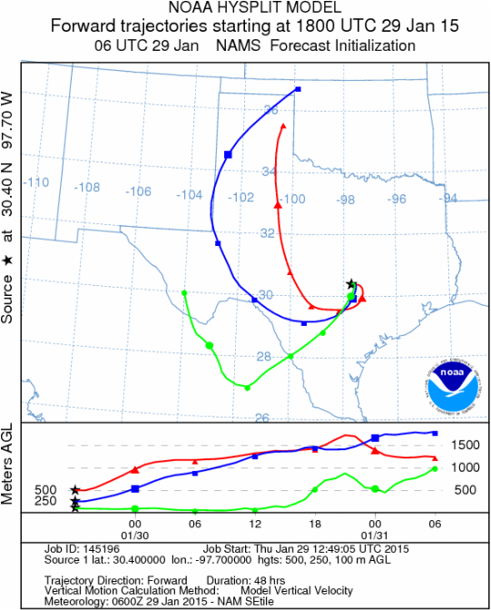
OUTLOOK: ***Severe Threat today and High threat Tomorrow. Today and tomorrow conditions will continue to be very good for pollen dispersal. Entrainment and downwind travel will occur, with the winds building and changing direction over the forecast period. High temperatures will climb in to the upper 60s and low 70s today and then cool by upwards of 20 degrees tomorrow. Winds at the surface will start somewhat mixed at light levels, but will build from the north and northeast overnight. The trajectories move to the southwest, then hook back northward to the west along the Texas/New Mexico border area. The trajectories will have significant pollen entrained within the and will bring significant concentrations over western regions.
Mountain Cedar location(s): Edwards Plateau, Texas.
Regional weather: Thursday, January 29 – TX/OK: Across the region today conditions will be mostly sunny to the north and partly cloudy building to mostly cloudy to the south. Temperatures will remain warm with the Edwards Plateau region in the upper 60s and low 70s. To the north, the Dallas/Ft. Worth metro region will top out in the low 60s and the border region will stay in the upper 50s. Winds will start from the north and northeast across the Edwards Plateau northward. To the north winds will be moderate to strong to begin the day. Those conditions will move southward and then start to rotate coming more from the northeast this afternoon. Tonight partly cloudy skies will occur to the north and across and around the edge of the Edwards Plateau mostly cloudy conditions will build. Low temperatures will be in the 40s to the east and 30s toward the western side of the Plateau. In southern Oklahoma lows will drop into the mid-30s. Winds will be from the northeast at moderate levels (10 to 15 miles per hour). Tomorrow, northern areas will begin the day partly cloudy with high temperatures in the lower 50s. Winds will be light from the east. To the south across Texas, mostly cloudy conditions will build in areas surrounding the Edwards Plateau from the Dallas/Ft. Worth metro area to San Antonio. On the Plateau cloudy conditions will prevail. There will be a 20% to 30% chance of rain to the east and a 60% to 70% chance of rain on the western side of the Edwards Plateau. Lows will remain in the 40s and winds will be light to moderate from the east
Trajectory weather: Air mass trajectories over Texas will be mixed today with conditions to the north and along the eastern side of the Edwards Plateau somewhat mixed. On the western side of the Plateau, however, conditions will begin to deteriorate with increasing clouds and the building o of north and northeasterly winds this afternoon and evening. Skies will begin to cloud over as the chance of rainfall creeps into the area tomorrow and then especially tomorrow night. Temperatures today will remain warm with the Plateau in the upper 60s and the surrounding communities in the 70s. Especially to the west winds will be moderately strong to entrain pollen and move it downwind. Overnight moisture will be moving in and cloudy skies building towards tomorrow morning. With the cloudy conditions temperatures tomorrow will stay in the 50s regionally. The southwestern areas of the Plateau will have the first chance, 20%, at rain under cloudy skies. Winds will be from the northeast at moderate conditions. Tomorrow, the chance of rain continues to be at its highest across the southwestern Plateau, 60% and 70%. To the north, however rain will be building overnight. Temperatures will remain in the 40s and winds will be from the east. Conditions are very good for pollen release across the region today but will begin to decline tomorrow. The air is relatively stable but we expect dispersal and long distance travel especially today and to a lesser degree tomorrow.
OUTLOOK: ***Severe Threat today and High threat Tomorrow. Today and tomorrow conditions will continue to be very good for pollen dispersal. Entrainment and downwind travel will occur, with the winds building and changing direction over the forecast period. High temperatures will climb in to the upper 60s and low 70s today and then cool by upwards of 20 degrees tomorrow. Winds at the surface will start somewhat mixed at light levels, but will build from the north and northeast overnight. The trajectories move to the southwest, then hook back northward to the west along the Texas/New Mexico border area. The trajectories will have significant pollen entrained within the and will bring significant concentrations over western regions.
Trajectory
Start (s) (shown by black stars on map):
Austin, TX
Austin, TX
Junction, TX
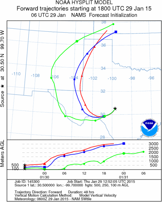
Sonora, TX

Matrix of sites across the Edwards Plateau (100 meters; 12:00 pm cst)
Prepared by: Estelle Levetin (Faculty of Biological Science, The University of Tulsa, 800 S. Tucker Dr., Tulsa, OK 74104) and Peter K Van de Water (Department of Earth and Environmental Science, California State University Fresno, 2576 East San Ramon Avenue, M/S ST24, Fresno CA 93740-8039). This forecast gives the anticipated future track of released Mountain Cedar pollen, weather conditions over the region and along the forecast pathway, and an estimated time of arrival for various metropolitan areas.Questions: Aerobiology Lab e-mail: [email protected]
Return to ForecastingHome Page
Return to ForecastingHome Page
