|
Metropolitan Area
Dallas Austin San Antonio |
Exposure Risk
High High High |
Date Issued: 30 January, 2015
Mountain Cedar location(s): Edwards Plateau, Texas.
Regional weather: Friday, January 30 – TX/OK: Across the region today conditions will be increasingly cloudy anticipating a rainy night and rain into tomorrow and tomorrow night. To the north in Oklahoma conditions will begin with partly cloudy skies with temperatures in the low 50s. To the south the Dallas/ Ft. Worth region will be partly sunny to begin with, however the mostly cloudy and cloudy conditions to the south across the Edwards Plateau will build in towards the afternoon. Temperatures will be cooling with highs today in the 50s across the area and in the mid to low 40s overnight. Today, there will be a chance of precipitation along the eastern edge communities and to the far western edge of the Edwards Plateau. Winds will be from the east at moderate levels. Tonight across the Edwards Plateau, cloudy conditions will dominate and temperatures will drop into the mid to low 40s. Winds will remain from the east to southeast at moderate conditions. To the north in Oklahoma winds will be light and variable. The western side of the Plateau will have a 70% chance of precipitation. In other areas will be less, but building towards tomorrow. On Saturday, cloudy conditions will prevail with significant chances of rain across the entire area (70% to 90%). Temperatures will be in the 50s across Texas and the 40s in southern Oklahoma. Winds will remain from the southeast at 10 to 15 miles per hour. Tomorrow night will almost be a duplicate of tomorrow day with cloudy skies significant chances of rain and winds mostly from the southeast. Temperatures tomorrow night will be in the 40s across the Plateau, low 50s in the surrounding communities and in the upper 30s to the north in Oklahoma. The extended forecast through the weekend calls for similar conditions.
Trajectory weather: Air mass trajectories over Texas will be influenced by the moisture in the atmosphere. High temperatures today will be in the 50s with a moderate wind from the east and northeast. As conditions deteriorate towards late afternoon and evening, moisture will be moving in from the southwest and west. By tonight the chance of rain will increase region wide. With the beginning of showers most of the pollen should be knocked down cleansing the atmosphere. Tonight temperatures will only fall by about 10 degrees and rains will become more widespread. Tomorrow a significant chance of rain will occur region-wide with temperatures similar to todays. Tomorrow night the rains will continue and temperatures vary only by about 10 degrees from daytime to nighttime. Conditions will begin at good conditions for pollen release across the region but will decline as moisture moves in.. There could be some dispersal today but with moister conditions dispersal and long distance travel should be limited
OUTLOOK: ***High Threat today and Low threat Tomorrow. Today conditions will continue to be good for pollen dispersal. Entrainment and downwind travel will occur today, before moisture moves in and dominates the conditions over the remaining forecast period. High temperatures will climb only in to the upper 50s and tomorrow. The chance of precipitation begins to build to the southwest today, then covers most of the entire area by tonight. Areas on the southwestern Edwards Plateau will have a 70% chance or precipitation tonight. Tomorrow, conditions deteriorate and most areas have precipitation. These conditions will continue into tomorrow night as well. The long term forecast show a bit of a break Saturday morning but then more moisture through the weekend. Some pollen will be entrained today and thus the High threat, but once the moisture moves in any pollen in the atmosphere will be washed out leaving a clean slate once the storm systems move on.
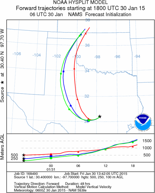
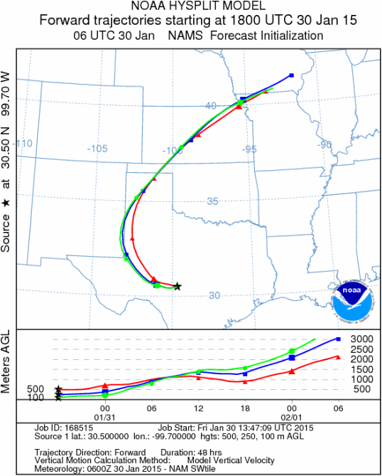
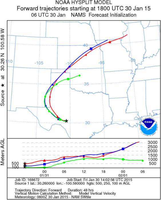
Trajectory Start (s) (shown by black stars on map):
Austin, TX
Junction, TX
Sonora, TX
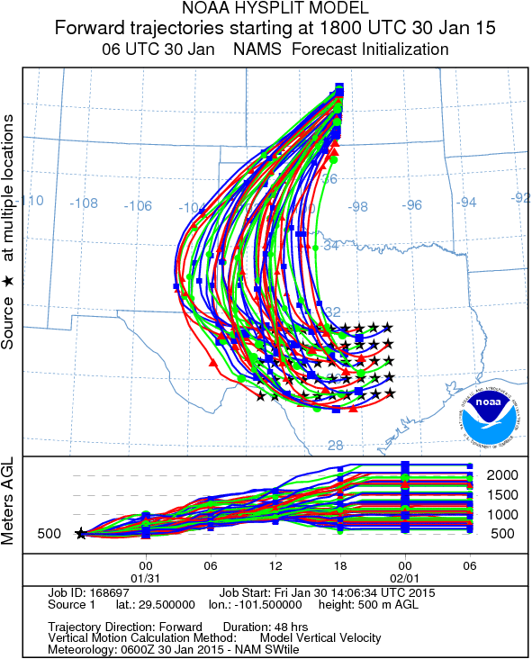
Matrix of sites across the Edwards Plateau (100 meters; 12:00 pm cst)
Prepared by: Estelle Levetin (Faculty of Biological Science, The University of Tulsa, 800 S. Tucker Dr., Tulsa, OK 74104) and Peter K Van de Water (Department of Earth and Environmental Science, California State University Fresno, 2576 East San Ramon Avenue, M/S ST24, Fresno CA 93740-8039). This forecast gives the anticipated future track of released Mountain Cedar pollen, weather conditions over the region and along the forecast pathway, and an estimated time of arrival for various metropolitan areas.Questions: Aerobiology Lab e-mail: [email protected]
Return to ForecastingHome Page
Return to ForecastingHome Page
