|
Metropolitan Area
Oklahoma City Tulsa St. Louis |
Exposure Risk
Moderate, High Moderate, High Low, Low |
Date Issued: 20 December 2014
Mountain Cedar location(s): Arbuckle Mountains, OK
Regional weather: Saturday and Sunday, December 20 and 21 – TX/OK: Across the region today skies will begin partly cloudy to mostly cloudy with morning fog. Temperatures will return to the 50’s region wide. Across the Edwards Plateau, winds will be from the south and southeast, but shifting to the northeast in the surrounding communities. Winds will be light regionally. Into the evening temperatures will fall into the 40’s, upper 30’ to the north in southern Oklahoma, with light winds continuing from the south. Skies will build from partly cloudy to mostly cloudy overnight. Temperatures will be seasonally mild with reading across the region in the 40’s. Tomorrow mostly cloudy skies will begin to break-up with the I-35 corridor becoming mostly sunny. Temperatures will climb into the upper 50’s with San Antonio expected to reach into the low 60’s. Winds will be from the southwest over the Edwards Plateau and from the south across the remainder of the region. In areas, such as the western side of the Plateau winds will build up to 10 to 15 miles per hour. Tomorrow night, cloudy skies will continue to dissipate, with the Edwards Plateau becoming mostly clear. The edge communities to the north will remain partly cloudy. Temperatures will be in the low 40s wand a dominant southerly flow will occur across the region for the entirety of the forecast area.
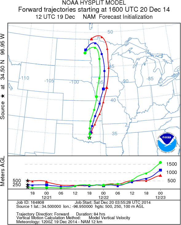
Trajectory weather: Air mass trajectories over southern Oklahoma will remain relatively stable not moving much, initially heading southward over northern Texas, then turning north on the overall southerly flow that develops into tomorrow. Temperatures will be mild with the border area reaching 50 degrees today. This morning will see ground fog under light and variable winds. Partly cloudy skies today will continue overnight with low temperatures dropping into the upper 30s. Winds along the border will remain light and variable. Tomorrow, temperatures will be in the lower 50’s with stronger winds from the south. Tomorrow night partly cloudy skies will continue with the low temperatures in the lower 40s and winds from the south at 10 miles per hour. The trajectories move initially southward over north Texas, then turn as southerly winds develop tomorrow morning. The strong winds will take material north potentially impacting central Oklahoma and areas northward. Pollen dispersal is expected both days, with the greater chance of heavy pollination, entrainment and travel on Sunday. Winds will be from the south at 5 to 10 miles per hour moving engrained pollen northward across Oklahoma, into the Midwest.
OUTLOOK: *** Moderate Threat today and High Threat Tomorrow *** moderate conditions for pollen release today with pollen ready to be dispersed but only light and variable winds. Concentrations may be heavy locally, but there will be less of a chance of long distance dispersal compared to tomorrow. The Arbuckle population will see improving conditions and a slight warmup on Sunday. High temperatures will be around 50 today and low 50s tomorrow. The cones on trees growing in the Arbuckle mountain area are shedding pollen. Overall conditions will be moderate today but with pollen in the air close to the populations. Tomorrow dispersal will occur and the stronger winds will be able to disperse it much further.
Trajectory Start (s) (shown by black star on map): Davis, OK.
Mountain Cedar location(s): Arbuckle Mountains, OK
Regional weather: Saturday and Sunday, December 20 and 21 – TX/OK: Across the region today skies will begin partly cloudy to mostly cloudy with morning fog. Temperatures will return to the 50’s region wide. Across the Edwards Plateau, winds will be from the south and southeast, but shifting to the northeast in the surrounding communities. Winds will be light regionally. Into the evening temperatures will fall into the 40’s, upper 30’ to the north in southern Oklahoma, with light winds continuing from the south. Skies will build from partly cloudy to mostly cloudy overnight. Temperatures will be seasonally mild with reading across the region in the 40’s. Tomorrow mostly cloudy skies will begin to break-up with the I-35 corridor becoming mostly sunny. Temperatures will climb into the upper 50’s with San Antonio expected to reach into the low 60’s. Winds will be from the southwest over the Edwards Plateau and from the south across the remainder of the region. In areas, such as the western side of the Plateau winds will build up to 10 to 15 miles per hour. Tomorrow night, cloudy skies will continue to dissipate, with the Edwards Plateau becoming mostly clear. The edge communities to the north will remain partly cloudy. Temperatures will be in the low 40s wand a dominant southerly flow will occur across the region for the entirety of the forecast area.
Trajectory weather: Air mass trajectories over southern Oklahoma will remain relatively stable not moving much, initially heading southward over northern Texas, then turning north on the overall southerly flow that develops into tomorrow. Temperatures will be mild with the border area reaching 50 degrees today. This morning will see ground fog under light and variable winds. Partly cloudy skies today will continue overnight with low temperatures dropping into the upper 30s. Winds along the border will remain light and variable. Tomorrow, temperatures will be in the lower 50’s with stronger winds from the south. Tomorrow night partly cloudy skies will continue with the low temperatures in the lower 40s and winds from the south at 10 miles per hour. The trajectories move initially southward over north Texas, then turn as southerly winds develop tomorrow morning. The strong winds will take material north potentially impacting central Oklahoma and areas northward. Pollen dispersal is expected both days, with the greater chance of heavy pollination, entrainment and travel on Sunday. Winds will be from the south at 5 to 10 miles per hour moving engrained pollen northward across Oklahoma, into the Midwest.
OUTLOOK: *** Moderate Threat today and High Threat Tomorrow *** moderate conditions for pollen release today with pollen ready to be dispersed but only light and variable winds. Concentrations may be heavy locally, but there will be less of a chance of long distance dispersal compared to tomorrow. The Arbuckle population will see improving conditions and a slight warmup on Sunday. High temperatures will be around 50 today and low 50s tomorrow. The cones on trees growing in the Arbuckle mountain area are shedding pollen. Overall conditions will be moderate today but with pollen in the air close to the populations. Tomorrow dispersal will occur and the stronger winds will be able to disperse it much further.
Trajectory Start (s) (shown by black star on map): Davis, OK.
Prepared by: Estelle Levetin (Faculty of Biological Science, The University of Tulsa, 800 S. Tucker Dr., Tulsa, OK 74104) and Peter K Van de Water (Department of Earth and Environmental Science, California State University Fresno, 2576 East San Ramon Avenue, M/S ST24, Fresno CA 93740-8039). This forecast gives the anticipated future track of released Mountain Cedar pollen, weather conditions over the region and along the forecast pathway, and an estimated time of arrival for various metropolitan areas.
Questions: Aerobiology Lab e-mail: [email protected]
Return to ForecastingHome Page
Questions: Aerobiology Lab e-mail: [email protected]
Return to ForecastingHome Page
