|
Metropolitan Area
Dallas Austin San Antonio |
Exposure Risk
Moderate High High to Severe |
Date Issued:
Mountain Cedar location(s): Edwards Plateau, Texas.
Regional weather: Tuesday, December 23 – TX/OK: Across the region today skies start mostly cloudy. Temperatures will be cooler, in the upper 40s to low 50s in southern Oklahoma area as well as in most areas along the I-35 corridor to the south in Texas. On the Edwards Plateau, high temperatures today will only be in the upper 40s to low 50s. These changes occur with northerly winds that will be 10 to 20 miles per hour. The northerly winds will also bring colder conditions with associated higher humidity and a chance of showers across the Edwards Plateau. As the afternoon wears on and into the evening conditions will begin to clear with partly cloudy skies and colder temperatures moving in. Overnight is southern Oklahoma lows will be in the mid-30s. Similar conditions will occur across Texas with lows in the mid to upper 30s. Winds will remain from the northwest and 10 to 15 mile per hour. Tomorrow, partly cloudy skies will remain across Oklahoma and the border area with Texas. High temperatures are expected to remain in the mid-40s with the moderate northwesterly winds. To the south partly cloudy conditions will begin to give way to partly sunny and then mostly sunny skies. High temperatures will be in the mid to lower 50s and the northwesterly winds will continue. Into the evening clear skies will remain and a shift in the winds will bring a southwesterly to westerly flow over the region. Low temperatures will be in the low 30s to the east and upper 20s over the Plateau to the west.
Trajectory weather: Air mass trajectories over Texas will be influenced by an overall flow from the north and northwest. The flow will occur today, tonight and tomorrow and bring cold air over the region. Today with the movement of air into Texas, has combined with moisture from the south to provide a chance of rain, 50%, across most of the Edwards Plateau and north into the Dallas/Ft. Worth region. Winds will be moderate with gusts at or above 20 miles per hour. As the day continues the chance of rain will diminish, and temperatures will drop into the 30’s. The air will be moving towards the south on the dominant northerly winds. The strong winds will entrain any pollen that is ready to be dispersed and will accumulate to significant concentrations for travel. Where rain showers occur, the air will be naturally cleansed of any pollen that is entrained. Also damp conditions within the trees may retard dispersal. Tonight conditions will begin to clear with continuing light to moderate winds. Tomorrow will be sunny across the region with northwest winds continuing. Pollen levels will return to heavy levels, moving from north to south. To recap, conditions today but especially tomorrow will be very good for pollen dispersal, entrainment and travel. In areas with trees heavy concentrations are expected. In those areas where precipitation develops, pollen will be washed out of the atmosphere and provide some measure of relief.
OUTLOOK: ****** Moderate to Severe Threat Today and High Threat Tomorrow *** Good conditions for pollen release today outside of areas with rain, where pollen is ready to be dispersed on moderate to strong winds from the north and northwest. Concentrations may be heavy locally The Edwards Plateau population will see poorer conditions with precipitation diminishing into the late afternoon and clear skies this evening. Overnight temperatures will fall into the 30s and then clear skies and high temperatures in the 50s tomorrow will increase the chance of significant pollen tomorrow. Overall conditions tomorrow will also be very good for dispersal, entrainment and downwind travel, although with the northern air flow over the region trajectories move due south.
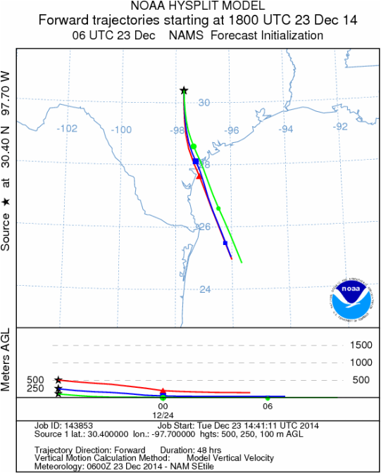
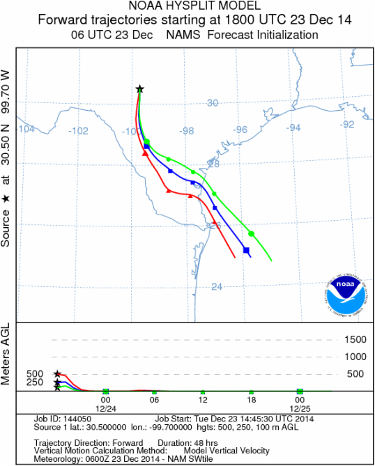
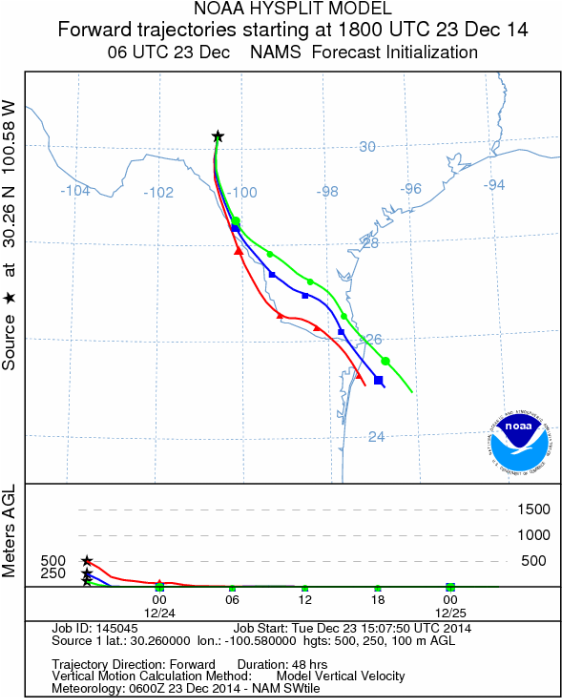
Trajectory Start (s) (shown by black stars on map):
Austin, TX
Junction, TX
Sonora, TX
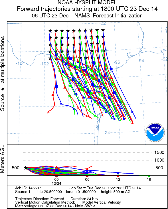
Matrix of sites across the Edwards Plateau (100 meters; 12:00 pm cst)
Prepared by: Estelle Levetin (Faculty of Biological Science, The University of Tulsa, 800 S. Tucker Dr., Tulsa, OK 74104) and Peter K Van de Water (Department of Earth and Environmental Science, California State University Fresno, 2576 East San Ramon Avenue, M/S ST24, Fresno CA 93740-8039). This forecast gives the anticipated future track of released Mountain Cedar pollen, weather conditions over the region and along the forecast pathway, and an estimated time of arrival for various metropolitan areas.Questions: Aerobiology Lab e-mail: [email protected]
Return to ForecastingHome Page
Return to ForecastingHome Page
